Peer night lights from space
Night Light of Peer (Flanders) from space (Belgium) Src. Average luminocity for 10x10km area is 8.8209% and for 50x50km: 24.5523%.
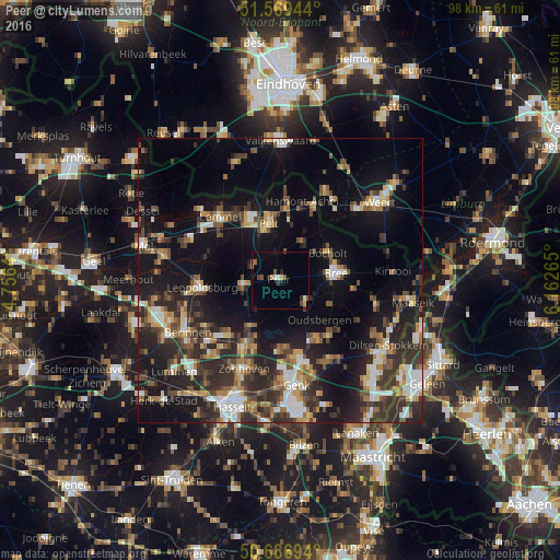
Analysis of Peer night lights 2016
Square area 10x10 km:
100  0.53%
0.53%
90-99 1.07%
80-89 0.13%
70-79 1.6%
60-69 0.13%
50-59 1.87%
40-49 2.27%
30-39 0.8%
20-29 1.6%
10-19 0.94%
0-9 89.04%
0.53%90-99
1.07%80-89
0.13%70-79
1.6%60-69
0.13%50-59
1.87%40-49
2.27%30-39
0.8%20-29
1.6%10-19
0.94%0-9
89.04%Square area 50x50 km:
100 2.92%
90-99 3.4%
80-89 2.22%
70-79 3%
60-69 3.05%
50-59 3.57%
40-49 4.44%
30-39 4.8%
20-29 9.27%
10-19 18.36%
0-9 44.96%
2.92%90-99
3.4%80-89
2.22%70-79
3%60-69
3.05%50-59
3.57%40-49
4.44%30-39
4.8%20-29
9.27%10-19
18.36%0-9
44.96%Clear (daylight) street map image can be seen on geolist.org.
Map coordinates:
51° 34' 10" North, 4° 45' 23" East
51° 7' 49.1" North, 5° 27' 34.3" East
50° 41' 13" North, 6° 9' 45.5" East
Some cities around Peer sort by population:
• Houthalen
12.2 km =7.6 mi,  209°
209°
• Helchteren
9.9 km =6.2 mi, 213°
• Neerpelt
10.9 km =6.8 mi,  353°
353°
• Bree
9.7 km =6 mi,  82°
82°
• Leopoldsburg
14.7 km =9.1 mi,  264°
264°
• Overpelt
9.4 km =5.8 mi,  341°
341°
• Bocholt
9.7 km =6 mi,  60°
60°
• Opglabbeek
13 km =8.1 mi,  138°
138°
2789232 (p: 15,551)
Sources (retrieved 2019-11-25):
» Earth at Night: Flat Maps 2012, 2016