Lochristi night lights from space
Night Light of Lochristi (Flanders) from space (Belgium) Src. Average luminocity for 10x10km area is 64.4011% and for 50x50km: 39.3828%.
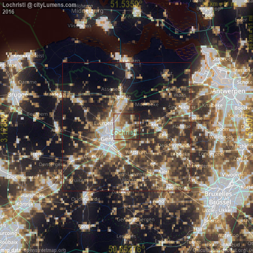
Analysis of Lochristi night lights 2016
Square area 10x10 km:
 9.09%
9.09%90-99
12.7%80-89
12.03%70-79
11.1%60-69
10.7%50-59
13.1%40-49
11.9%30-39
8.02%20-29
8.56%10-19
2.81%0-9
0%Square area 50x50 km:
4.5%90-99
5.8%80-89
4.18%70-79
4.86%60-69
6.43%50-59
7.49%40-49
9.89%30-39
9.28%20-29
14.53%10-19
15.98%0-9
17.05%Clear (daylight) street map image can be seen on geolist.org.
Map coordinates:
51° 32' 9.2" North, 3° 7' 43.8" East
51° 5' 47.2" North, 3° 49' 55" East
50° 39' 9.9" North, 4° 32' 6.3" East
Some cities around Lochristi sort by population:
• Gent
9.6 km =6 mi,  237°
237°
• Evergem
8.7 km =5.4 mi,  282°
282°
• Destelbergen
4.7 km =2.9 mi,  209°
209°
• Zelzate
10.5 km =6.5 mi,  350°
350°
• Laarne
7.4 km =4.6 mi,  169°
169°
• Melle
10.6 km =6.6 mi,  190°
190°
• Ledeberg
8.9 km =5.5 mi,  223°
223°
• Wachtebeke
8.5 km =5.3 mi,  19°
19°
2792235 (p: 19,696)
Sources (retrieved 2019-11-25):
» Earth at Night: Flat Maps 2012, 2016