Kortessem night lights from space
Night Light of Kortessem (Flanders) from space (Belgium) Src. Average luminocity for 10x10km area is 21.7339% and for 50x50km: 33.5255%.
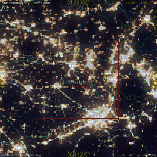
Analysis of Kortessem night lights 2016
Square area 10x10 km:
 0.14%
0.14%90-99
2.1%80-89
0.56%70-79
0.7%60-69
2.52%50-59
3.22%40-49
5.88%30-39
3.22%20-29
13.87%10-19
50%0-9
17.79%Square area 50x50 km:
4.84%90-99
5.56%80-89
2.65%70-79
3.32%60-69
4.71%50-59
4.84%40-49
5.78%30-39
6.59%20-29
12.91%10-19
27.11%0-9
21.71%Clear (daylight) street map image can be seen on geolist.org.
Map coordinates:
51° 18' 2.3" North, 4° 41' 11.8" East
50° 51' 32" North, 5° 23' 23.1" East
50° 24' 46.6" North, 6° 5' 34.3" East
Some cities around Kortessem sort by population:
• Hasselt
8.8 km =5.5 mi,  335°
335°
• Tongeren
10.2 km =6.3 mi,  148°
148°
• Bilzen
9.2 km =5.7 mi,  79°
79°
• Diepenbeek
5.8 km =3.6 mi,  20°
20°
• Alken
6.2 km =3.9 mi,  287°
287°
• Borgloon
6.8 km =4.2 mi,  208°
208°
• Hoeselt
7 km =4.3 mi,  100°
100°
• Wellen
4.1 km =2.5 mi,  240°
240°
2794063 (p: 8,042)
Sources (retrieved 2019-11-25):
» Earth at Night: Flat Maps 2012, 2016