Diepenbeek night lights from space
Night Light of Diepenbeek (Flanders) from space (Belgium) Src. Average luminocity for 10x10km area is 43.7199% and for 50x50km: 31.1797%.
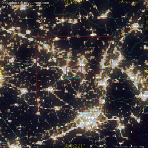
Analysis of Diepenbeek night lights 2016
Square area 10x10 km:
100  6.02%
6.02%
90-99 8.12%
80-89 1.4%
70-79 4.48%
60-69 8.12%
50-59 4.2%
40-49 11.2%
30-39 12.04%
20-29 23.39%
10-19 21.01%
0-9 0%
6.02%90-99
8.12%80-89
1.4%70-79
4.48%60-69
8.12%50-59
4.2%40-49
11.2%30-39
12.04%20-29
23.39%10-19
21.01%0-9
0%Square area 50x50 km:
100 3.63%
90-99 4.44%
80-89 2.45%
70-79 3.29%
60-69 4.5%
50-59 4.75%
40-49 5.8%
30-39 6.53%
20-29 13.89%
10-19 27.15%
0-9 23.56%
3.63%90-99
4.44%80-89
2.45%70-79
3.29%60-69
4.5%50-59
4.75%40-49
5.8%30-39
6.53%20-29
13.89%10-19
27.15%0-9
23.56%Clear (daylight) street map image can be seen on geolist.org.
Map coordinates:
51° 20' 56.2" North, 4° 42' 56.2" East
50° 54' 27.7" North, 5° 25' 7.5" East
50° 27' 44" North, 6° 7' 18.7" East
Some cities around Diepenbeek sort by population:
• Hasselt
6.2 km =3.9 mi,  294°
294°
• Genk
8.6 km =5.3 mi,  42°
42°
• Bilzen
8 km =5 mi,  118°
118°
• Zonhoven
9.9 km =6.2 mi,  338°
338°
• Alken
8.7 km =5.4 mi,  245°
245°
• Hoeselt
8.3 km =5.2 mi,  144°
144°
• Kortessem
5.8 km =3.6 mi,  200°
200°
• Wellen
9.3 km =5.8 mi,  217°
217°
2799412 (p: 17,699)
Sources (retrieved 2019-11-25):
» Earth at Night: Flat Maps 2012, 2016