Kapelle-op-den-Bos night lights from space
Night Light of Kapelle-op-den-Bos (Flanders) from space (Belgium) Src. Average luminocity for 10x10km area is 62.5588% and for 50x50km: 60.4777%.
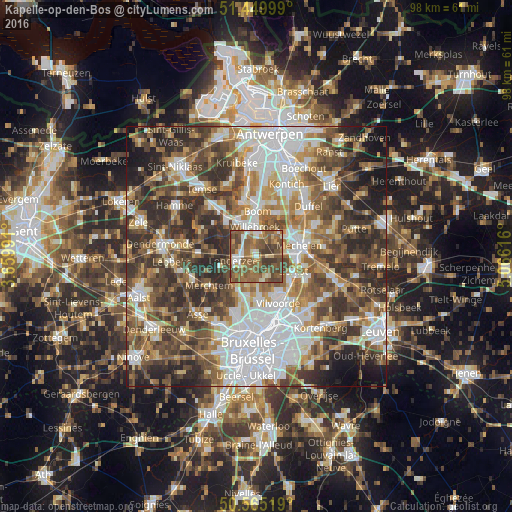
Analysis of Kapelle-op-den-Bos night lights 2016
Square area 10x10 km:
 6.55%
6.55%90-99
9.36%80-89
4.81%70-79
7.49%60-69
15.78%50-59
30.48%40-49
17.25%30-39
8.29%20-29
0%10-19
0%0-9
0%Square area 50x50 km:
14.73%90-99
11.44%80-89
5.66%70-79
6.97%60-69
9.21%50-59
10.76%40-49
12.09%30-39
11.07%20-29
11.7%10-19
5.43%0-9
0.94%Clear (daylight) street map image can be seen on geolist.org.
Map coordinates:
51° 26' 60" North, 3° 39' 35.7" East
51° 0' 34.9" North, 4° 21' 46.9" East
50° 33' 54.7" North, 5° 3' 58.2" East
Some cities around Kapelle-op-den-Bos sort by population:
• Mechelen
8.2 km =5.1 mi,  77°
77°
• Grimbergen
8.4 km =5.2 mi,  175°
175°
• Willebroek
5.6 km =3.5 mi,  357°
357°
• Zemst
7.4 km =4.6 mi,  113°
113°
• Meise
8.2 km =5.1 mi,  198°
198°
• Londerzeel
4.2 km =2.6 mi,  262°
262°
• Puurs
8.9 km =5.5 mi,  323°
323°
• Rumst
9 km =5.6 mi,  27°
27°
2794724 (p: 8,859)
Sources (retrieved 2019-11-25):
» Earth at Night: Flat Maps 2012, 2016