Herzele night lights from space
Night Light of Herzele (Flanders) from space (Belgium) Src. Average luminocity for 10x10km area is 40.4146% and for 50x50km: 40.1492%.
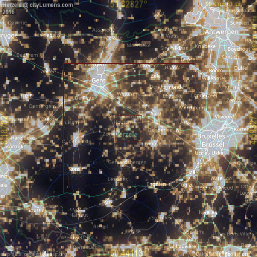
Analysis of Herzele night lights 2016
Square area 10x10 km:
 1.12%
1.12%90-99
4.06%80-89
4.62%70-79
5.88%60-69
6.16%50-59
9.66%40-49
7.28%30-39
12.75%20-29
34.03%10-19
14.43%0-9
0%Square area 50x50 km:
4.36%90-99
5.61%80-89
4.04%70-79
4.79%60-69
6.21%50-59
8.7%40-49
10.39%30-39
10%20-29
15.43%10-19
16.02%0-9
14.45%Clear (daylight) street map image can be seen on geolist.org.
Map coordinates:
51° 19' 41.8" North, 3° 11' 13.3" East
50° 53' 12.5" North, 3° 53' 24.5" East
50° 26' 28.1" North, 4° 35' 35.8" East
Some cities around Herzele sort by population:
• Aalst
11.6 km =7.2 mi,  61°
61°
• Ninove
11.6 km =7.2 mi,  124°
124°
• Zottegem
5.9 km =3.7 mi,  251°
251°
• Haaltert
8.1 km =5 mi,  74°
74°
• Lede
11.1 km =6.9 mi,  37°
37°
• Oosterzele
9.7 km =6 mi,  318°
318°
• Sint-Lievens-Houtem
4.1 km =2.5 mi,  331°
331°
• Sint-Maria-Lierde
8.2 km =5.1 mi,  202°
202°
2795908 (p: 16,523)
Sources (retrieved 2019-11-25):
» Earth at Night: Flat Maps 2012, 2016