Dentergem night lights from space
Night Light of Dentergem (Flanders) from space (Belgium) Src. Average luminocity for 10x10km area is 30.5854% and for 50x50km: 39.3782%.
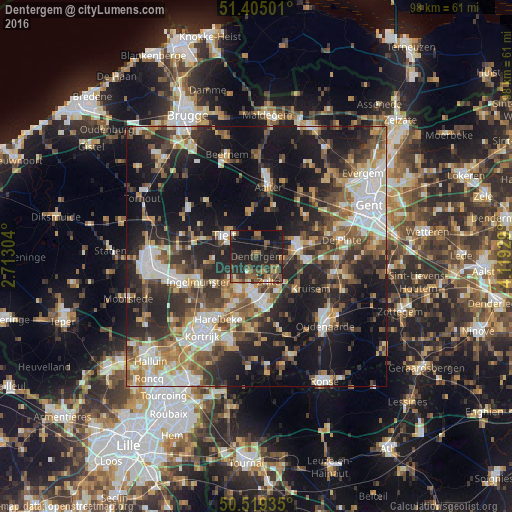
Analysis of Dentergem night lights 2016
Square area 10x10 km:
 0.28%
0.28%90-99
2.1%80-89
2.38%70-79
1.54%60-69
4.9%50-59
8.54%40-49
8.82%30-39
6.44%20-29
22.55%10-19
36.41%0-9
6.02%Square area 50x50 km:
6.25%90-99
6.98%80-89
3.82%70-79
4.55%60-69
5.5%50-59
6.75%40-49
6.12%30-39
6.74%20-29
13.6%10-19
24.06%0-9
15.64%Clear (daylight) street map image can be seen on geolist.org.
Map coordinates:
51° 24' 18" North, 2° 42' 46.9" East
50° 57' 51.4" North, 3° 24' 58.2" East
50° 31' 9.7" North, 4° 7' 9.4" East
Some cities around Dentergem sort by population:
• Waregem
8.4 km =5.2 mi,  174°
174°
• Deinze
8.3 km =5.2 mi,  76°
76°
• Tielt
7.4 km =4.6 mi,  301°
301°
• Zulte
5.5 km =3.4 mi,  155°
155°
• Meulebeke
9.1 km =5.7 mi,  260°
260°
• Wielsbeke
7.9 km =4.9 mi,  205°
205°
• Oostrozebeke
7.3 km =4.5 mi,  228°
228°
• Ruiselede
8.6 km =5.3 mi,  349°
349°
2799586 (p: 8,038)
Sources (retrieved 2019-11-25):
» Earth at Night: Flat Maps 2012, 2016