Ruiselede night lights from space
Night Light of Ruiselede (Flanders) from space (Belgium) Src. Average luminocity for 10x10km area is 19.7874% and for 50x50km: 36.7439%.
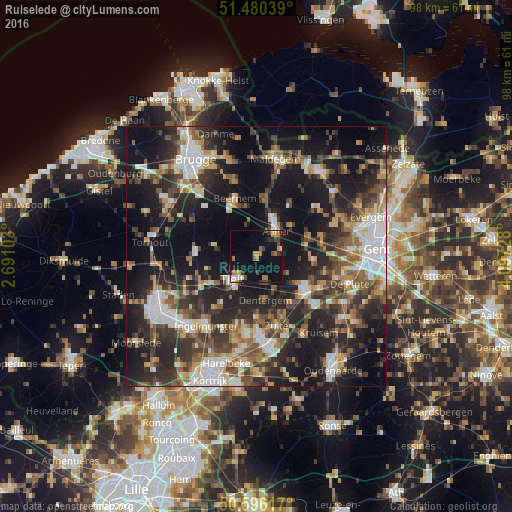
Analysis of Ruiselede night lights 2016
Square area 10x10 km:
 1.34%
1.34%90-99
1.74%80-89
0.67%70-79
4.14%60-69
3.88%50-59
2.27%40-49
2.94%30-39
2.81%20-29
2.41%10-19
21.39%0-9
56.42%Square area 50x50 km:
5.39%90-99
6.12%80-89
3.35%70-79
4.08%60-69
4.69%50-59
6.38%40-49
6.14%30-39
7.11%20-29
13.65%10-19
25.78%0-9
17.32%Clear (daylight) street map image can be seen on geolist.org.
Map coordinates:
51° 28' 49.4" North, 2° 41' 27.7" East
51° 2' 25.4" North, 3° 23' 39" East
50° 35' 46.2" North, 4° 5' 50.2" East
Some cities around Ruiselede sort by population:
• Deinze
11.6 km =7.2 mi,  124°
124°
• Tielt
6.5 km =4 mi,  225°
225°
• Aalter
6.7 km =4.2 mi,  33°
33°
• Wingene
8.6 km =5.3 mi,  282°
282°
• Nevele
10.6 km =6.6 mi,  93°
93°
• Dentergem
8.6 km =5.3 mi,  169°
169°
• Knesselare
11.1 km =6.9 mi,  6°
6°
• Pittem
10.6 km =6.6 mi,  239°
239°
2787547 (p: 5,129)
Sources (retrieved 2019-11-25):
» Earth at Night: Flat Maps 2012, 2016