Sanski Most night lights from space
Night Light of Sanski Most (Federation of B&H) from space (Bosnia and Herzegovina) Src. Average luminocity for 10x10km area is 1.6636% and for 50x50km: 0.6812%.
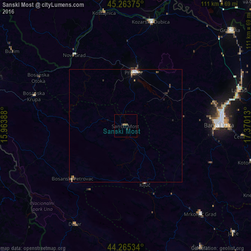
Analysis of Sanski Most night lights 2016
Square area 10x10 km:
 0%
0%90-99
0%80-89
0%70-79
0%60-69
1.21%50-59
0.61%40-49
0%30-39
0.76%20-29
0.45%10-19
0%0-9
96.97%Square area 50x50 km:
0.09%90-99
0.09%80-89
0.05%70-79
0.07%60-69
0.1%50-59
0.12%40-49
0.17%30-39
0.11%20-29
0.23%10-19
0.1%0-9
98.89%Clear (daylight) street map image can be seen on geolist.org.
Map coordinates:
45° 15' 49.5" North, 15° 57' 50" East
44° 46' 0.1" North, 16° 40' 1.2" East
44° 15' 55.2" North, 17° 22' 12.5" East
Some cities around Sanski Most sort by population:
• Banja Luka
41.6 km =25.8 mi,  88°
88°
• Prijedor
24 km =14.9 mi,  8°
8°
• Bosanska Krupa
42.7 km =26.5 mi,  287°
287°
• Novi Grad
38.5 km =23.9 mi,  323°
323°
• Ključ
27.5 km =17.1 mi,  161°
161°
• Omarska
22.9 km =14.2 mi,  52°
52°
• Sanica
17.2 km =10.7 mi,  186°
186°
• Mejdan - Obilićevo
41.3 km =25.7 mi, 90°
3191297 (p: 13,551)
Sources (retrieved 2019-11-25):
» Earth at Night: Flat Maps 2012, 2016