Donja Mahala night lights from space
Night Light of Donja Mahala (Federation of B&H) from space (Bosnia and Herzegovina) Src. Average luminocity for 10x10km area is 16.0227% and for 50x50km: 4.5123%.
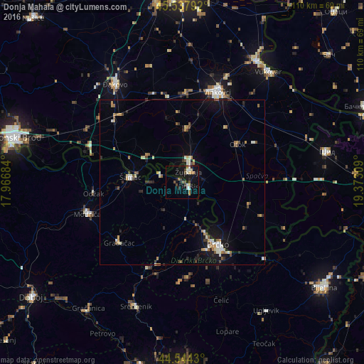
Analysis of Donja Mahala night lights 2016
Square area 10x10 km:
 1.21%
1.21%90-99
3.33%80-89
1.82%70-79
0.91%60-69
2.42%50-59
1.36%40-49
3.48%30-39
0.76%20-29
2.27%10-19
18.03%0-9
64.39%Square area 50x50 km:
0.31%90-99
0.77%80-89
0.47%70-79
0.57%60-69
0.51%50-59
0.64%40-49
0.62%30-39
0.48%20-29
0.68%10-19
3.39%0-9
91.56%Clear (daylight) street map image can be seen on geolist.org.
Map coordinates:
45° 32' 16.5" North, 17° 58' 0.6" East
45° 2' 35.8" North, 18° 40' 11.9" East
44° 32' 39.5" North, 19° 22' 23.1" East
Some cities around Donja Mahala sort by population:
• Brčko
22.2 km =13.8 mi,  150°
150°
• Gradačac
26.4 km =16.4 mi,  226°
226°
• Županja, HR
4.4 km =2.7 mi,  29°
29°
• Odžak
27.5 km =17.1 mi,  265°
265°
• Mionica
25.4 km =15.8 mi,  219°
219°
• Ivankovo, HR
27.3 km =17 mi,  2°
2°
• Otok, HR
20.4 km =12.7 mi,  55°
55°
• Gunja, HR
23.2 km =14.4 mi,  141°
141°
3201662 (p: 5,565)
Sources (retrieved 2019-11-25):
» Earth at Night: Flat Maps 2012, 2016