Qızılhacılı night lights from space
Night Light of Qızılhacılı (Goranboy) from space (Azerbaijan) Src. Average luminocity for 10x10km area is 2.4984% and for 50x50km: 4.099%.
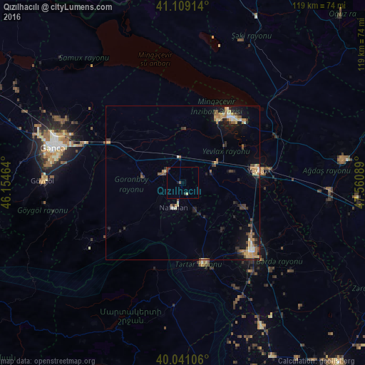
Analysis of Qızılhacılı night lights 2016
Square area 10x10 km:
 0%
0%90-99
0%80-89
0.65%70-79
0%60-69
0.32%50-59
0.97%40-49
0%30-39
0.65%20-29
0.65%10-19
0.65%0-9
96.1%Square area 50x50 km:
0.18%90-99
0.5%80-89
0.59%70-79
0.59%60-69
0.71%50-59
0.77%40-49
0.59%30-39
0.59%20-29
1.05%10-19
2.45%0-9
91.97%Clear (daylight) street map image can be seen on geolist.org.
Map coordinates:
41° 6' 32.9" North, 46° 9' 16.7" East
40° 34' 38" North, 46° 51' 27.9" East
40° 2' 27.8" North, 47° 33' 39.2" East
Some cities around Qızılhacılı sort by population:
• Yevlakh
25.1 km =15.6 mi,  79°
79°
• Mingelchaur
26.8 km =16.7 mi,  39°
39°
• Barda
31.9 km =19.8 mi,  134°
134°
• Terter
26.9 km =16.7 mi,  166°
166°
• Martakert
40.8 km =25.4 mi,  184°
184°
• Goranboy
6.8 km =4.2 mi,  302°
302°
• Naftalan
8.3 km =5.2 mi,  202°
202°
• Aran
11.3 km =7 mi,  61°
61°
585666 (p: 6,330)
Sources (retrieved 2019-11-25):
» Earth at Night: Flat Maps 2012, 2016