Avşar night lights from space
Night Light of Avşar (Ağcabǝdi) from space (Azerbaijan) Src. Average luminocity for 10x10km area is 3.7585% and for 50x50km: 3.0403%.
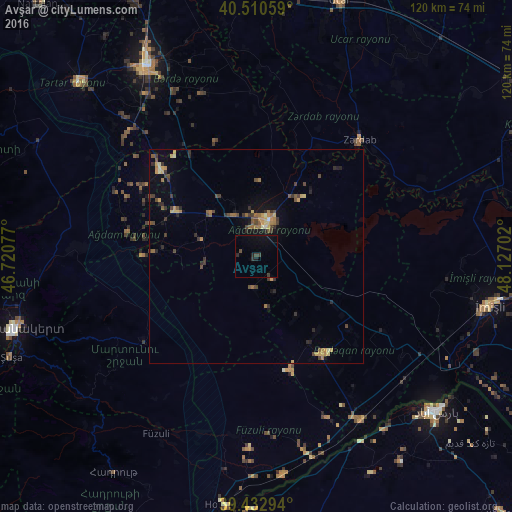
Analysis of Avşar night lights 2016
Square area 10x10 km:
 0%
0%90-99
0%80-89
0%70-79
0%60-69
0%50-59
0%40-49
0.85%30-39
1.87%20-29
2.04%10-19
3.91%0-9
91.33%Square area 50x50 km:
0.01%90-99
0.14%80-89
0.44%70-79
0.48%60-69
0.63%50-59
0.39%40-49
0.72%30-39
0.85%20-29
0.75%10-19
1.07%0-9
94.52%Clear (daylight) street map image can be seen on geolist.org.
Map coordinates:
40° 30' 38.1" North, 46° 43' 14.8" East
39° 58' 26" North, 47° 25' 26" East
39° 25' 58.6" North, 48° 7' 37.3" East
Some cities around Avşar sort by population:
• Ağdam
42.3 km =26.3 mi,  272°
272°
• Barda
51.3 km =31.9 mi,  330°
330°
• Agdzhabedy
9 km =5.6 mi,  19°
19°
• Fizuli
47.8 km =29.7 mi,  209°
209°
• Beylagan
27.6 km =17.1 mi,  143°
143°
• Zardob
36.6 km =22.7 mi,  42°
42°
• Dünyamalılar
36.3 km =22.6 mi,  128°
128°
• Novyy Karanlug
33.2 km =20.6 mi,  233°
233°
393927 (p: 5,600)
Sources (retrieved 2019-11-25):
» Earth at Night: Flat Maps 2012, 2016