Cecil Hills night lights from space
Night Light of Cecil Hills (New South Wales) from space (Australia) Src. Average luminocity for 10x10km area is 65.0175% and for 50x50km: 48.765%.
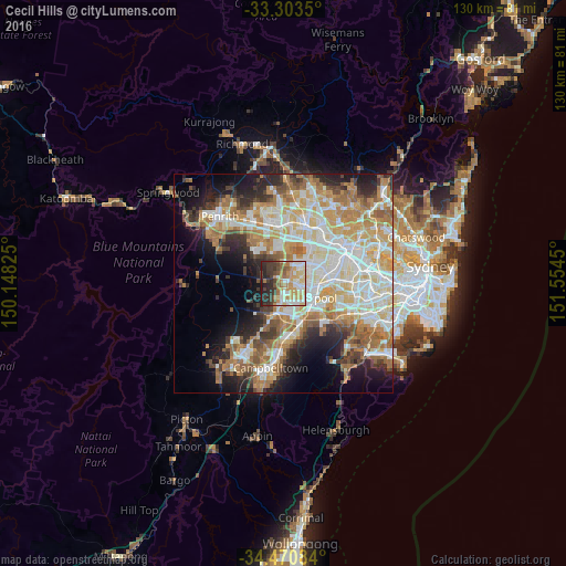
Analysis of Cecil Hills night lights 2016
Square area 10x10 km:
 11.01%
90-99
15.21%80-89
9.62%70-79
15.21%60-69
9.79%50-59
6.12%40-49
4.9%30-39
13.29%20-29
13.11%10-19
1.75%0-9
0%Square area 50x50 km:
10.03%90-99
11.82%80-89
6.77%70-79
8.01%60-69
9.17%50-59
5.14%40-49
3.75%30-39
4.97%20-29
6.52%10-19
9.44%0-9
24.39%Clear (daylight) street map image can be seen on geolist.org.
Map coordinates:
33° 18' 12.6" South, 150° 8' 53.7" East
33° 53' 21" South, 150° 51' 4.9" East
34° 28' 15" South, 151° 33' 16.2" East
Some cities around Cecil Hills sort by population:
• Bossley Park
4.3 km =2.7 mi,  44°
44°
• Green Valley
2.1 km =1.3 mi,  136°
136°
• Hinchinbrook
3.5 km =2.2 mi,  161°
161°
• Edensor Park
2.7 km =1.7 mi,  66°
66°
• Bonnyrigg
3.5 km =2.2 mi,  98°
98°
• Bonnyrigg Heights
1.7 km =1.1 mi, 97°
• Middleton Grange
3.2 km =2 mi,  195°
195°
• Greenfield Park
4.1 km =2.5 mi, 66°
8348484 (p: 6,924)
Sources (retrieved 2019-11-25):
» Earth at Night: Flat Maps 2012, 2016