Wentworth Falls night lights from space
Night Light of Wentworth Falls (New South Wales) from space (Australia) Src. Average luminocity for 10x10km area is 10.1099% and for 50x50km: 2.061%.
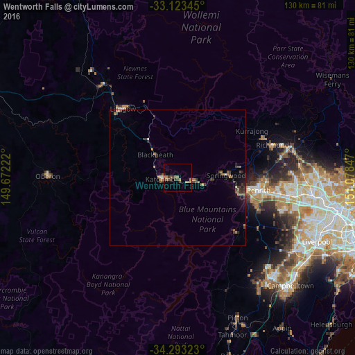
Analysis of Wentworth Falls night lights 2016
Square area 10x10 km:
 0%
0%90-99
0%80-89
0%70-79
2.38%60-69
4.58%50-59
1.1%40-49
2.2%30-39
3.48%20-29
0.92%10-19
0%0-9
85.35%Square area 50x50 km:
0.06%90-99
0.09%80-89
0.08%70-79
0.3%60-69
0.62%50-59
0.25%40-49
0.49%30-39
0.71%20-29
0.3%10-19
0.86%0-9
96.22%Clear (daylight) street map image can be seen on geolist.org.
Map coordinates:
33° 7' 24.4" South, 149° 40' 20" East
33° 42' 37.2" South, 150° 22' 31.2" East
34° 17' 35.6" South, 151° 4' 42.5" East
Some cities around Wentworth Falls sort by population:
• Glenmore Park
28.6 km =17.8 mi,  108°
108°
• Penrith
30.3 km =18.8 mi,  98°
98°
• Emu Plains
27.3 km =17 mi, 99°
• Springwood
16.2 km =10.1 mi,  85°
85°
• Katoomba
6.4 km =4 mi,  260°
260°
• Blaxland
21.2 km =13.2 mi, 101°
• Winmalee
22.2 km =13.8 mi,  80°
80°
• Jamisontown
28.6 km =17.8 mi, 102°
2144127 (p: 5,928)
Sources (retrieved 2019-11-25):
» Earth at Night: Flat Maps 2012, 2016