Winmalee night lights from space
Night Light of Winmalee (New South Wales) from space (Australia) Src. Average luminocity for 10x10km area is 8.3974% and for 50x50km: 14.102%.
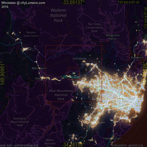
Analysis of Winmalee night lights 2016
Square area 10x10 km:
 0.55%
0.55%90-99
0.18%80-89
0.37%70-79
0%60-69
2.2%50-59
1.65%40-49
1.83%30-39
1.65%20-29
1.28%10-19
9.52%0-9
80.77%Square area 50x50 km:
1.96%90-99
2.26%80-89
1.11%70-79
2.48%60-69
3.39%50-59
1.54%40-49
2.14%30-39
2.9%20-29
3.33%10-19
5.36%0-9
73.53%Clear (daylight) street map image can be seen on geolist.org.
Map coordinates:
33° 5' 28.9" South, 149° 54' 32.4" East
33° 40' 42.5" South, 150° 36' 43.7" East
34° 15' 41.7" South, 151° 18' 54.9" East
Some cities around Winmalee sort by population:
• Cranebrook
9.5 km =5.9 mi,  108°
108°
• Penrith
11.4 km =7.1 mi,  134°
134°
• Emu Plains
9.4 km =5.8 mi,  147°
147°
• Springwood
6.2 km =3.9 mi,  247°
247°
• Blaxland
8 km =5 mi,  188°
188°
• Cambridge Park
12.8 km =8 mi, 127°
• Jamisontown
11.6 km =7.2 mi, 148°
• Jordan Springs
11.8 km =7.3 mi, 113°
8347779 (p: 6,057)
Sources (retrieved 2019-11-25):
» Earth at Night: Flat Maps 2012, 2016