Tahmoor night lights from space
Night Light of Tahmoor (New South Wales) from space (Australia) Src. Average luminocity for 10x10km area is 8.4597% and for 50x50km: 6.7389%.
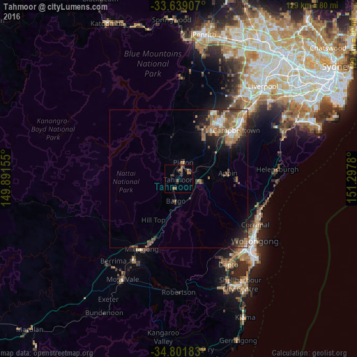
Analysis of Tahmoor night lights 2016
Square area 10x10 km:
 0%
0%90-99
0%80-89
0%70-79
0.37%60-69
4.95%50-59
1.83%40-49
1.47%30-39
4.21%20-29
1.83%10-19
0%0-9
85.35%Square area 50x50 km:
0.75%90-99
0.73%80-89
0.46%70-79
0.74%60-69
2.01%50-59
1.66%40-49
1.08%30-39
1.32%20-29
1.28%10-19
3.06%0-9
86.89%Clear (daylight) street map image can be seen on geolist.org.
Map coordinates:
33° 38' 20.7" South, 149° 53' 29.6" East
34° 13' 20.9" South, 150° 35' 40.8" East
34° 48' 6.6" South, 151° 17' 52.1" East
Some cities around Tahmoor sort by population:
• Mount Annan
24.2 km =15 mi,  38°
38°
• Harrington Park
25.6 km =15.9 mi,  30°
30°
• Bradbury
25.4 km =15.8 mi,  53°
53°
• Rosemeadow
22.5 km =14 mi, 54°
• Ambarvale
23.7 km =14.7 mi, 51°
• Narellan Vale
23.6 km =14.7 mi, 35°
• St Helens Park
24 km =14.9 mi,  56°
56°
• Currans Hill
25.8 km =16 mi, 39°
2147618 (p: 5,016)
Sources (retrieved 2019-11-25):
» Earth at Night: Flat Maps 2012, 2016