Sorrento night lights from space
Night Light of Sorrento (Western Australia) from space (Australia) Src. Average luminocity for 10x10km area is 59.5842% and for 50x50km: 32.1757%.
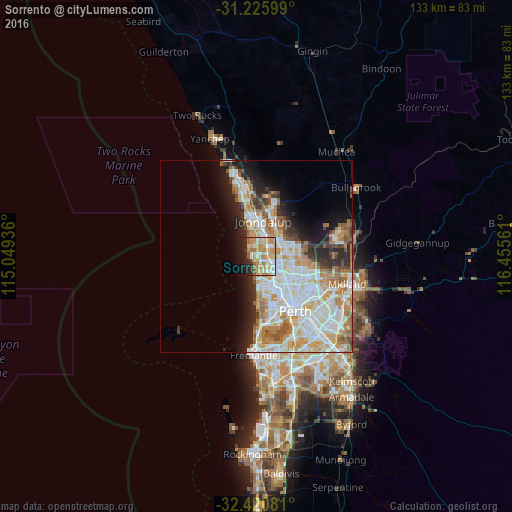
Analysis of Sorrento night lights 2016
Square area 10x10 km:
 7.69%
7.69%90-99
11.54%80-89
10.99%70-79
17.95%60-69
14.29%50-59
4.03%40-49
0.73%30-39
1.83%20-29
13.19%10-19
14.29%0-9
3.48%Square area 50x50 km:
8.04%90-99
8.44%80-89
3.66%70-79
4.91%60-69
5.43%50-59
2.75%40-49
1.86%30-39
2.29%20-29
4.9%10-19
6.59%0-9
51.15%Clear (daylight) street map image can be seen on geolist.org.
Map coordinates:
31° 13' 33.6" South, 115° 2' 57.7" East
31° 49' 31.2" South, 115° 45' 8.9" East
32° 25' 14.9" South, 116° 27' 20.2" East
Some cities around Sorrento sort by population:
• Duncraig
2.4 km =1.5 mi,  110°
110°
• Kingsley
4.9 km =3 mi,  69°
69°
• Hillarys
2.3 km =1.4 mi,  330°
330°
• Greenwood
4.7 km =2.9 mi,  92°
92°
• Padbury
2.6 km =1.6 mi,  36°
36°
• Carine
4.1 km =2.5 mi,  136°
136°
• Craigie
4.5 km =2.8 mi,  21°
21°
• Kallaroo
3.8 km =2.4 mi,  0°
0°
8261095 (p: 7,148)
Sources (retrieved 2019-11-25):
» Earth at Night: Flat Maps 2012, 2016