Hillarys night lights from space
Night Light of Hillarys (Western Australia) from space (Australia) Src. Average luminocity for 10x10km area is 52.5568% and for 50x50km: 29.6089%.
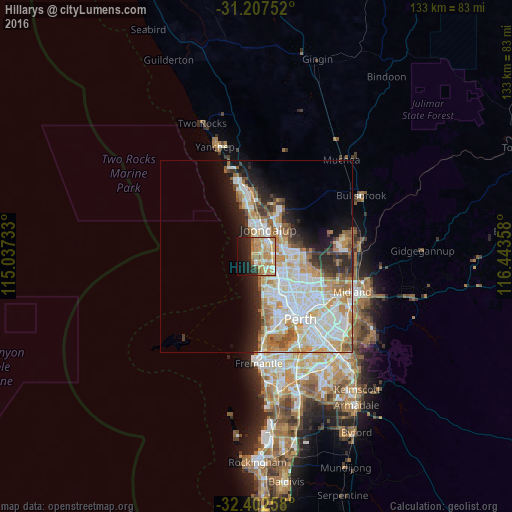
Analysis of Hillarys night lights 2016
Square area 10x10 km:
 6.59%
6.59%90-99
8.06%80-89
8.42%70-79
16.48%60-69
14.47%50-59
3.85%40-49
0.73%30-39
1.83%20-29
13.19%10-19
15.38%0-9
10.99%Square area 50x50 km:
7.51%90-99
7.82%80-89
3.12%70-79
4.34%60-69
4.96%50-59
2.4%40-49
1.77%30-39
2.2%20-29
4.75%10-19
6.83%0-9
54.31%Clear (daylight) street map image can be seen on geolist.org.
Map coordinates:
31° 12' 27.1" South, 115° 2' 14.4" East
31° 48' 25.1" South, 115° 44' 25.6" East
32° 24' 9.3" South, 116° 26' 36.9" East
Some cities around Hillarys sort by population:
• Duncraig
4.4 km =2.7 mi,  130°
130°
• Padbury
2.7 km =1.7 mi,  88°
88°
• Ocean Reef
5.4 km =3.4 mi,  355°
355°
• Sorrento
2.3 km =1.4 mi,  150°
150°
• Heathridge
5.3 km =3.3 mi,  19°
19°
• Mullaloo
3.1 km =1.9 mi,  353°
353°
• Craigie
3.5 km =2.2 mi,  51°
51°
• Kallaroo
2.1 km =1.3 mi,  33°
33°
6621336 (p: 10,603)
Sources (retrieved 2019-11-25):
» Earth at Night: Flat Maps 2012, 2016