Peregian Springs night lights from space
Night Light of Peregian Springs (Queensland) from space (Australia) Src. Average luminocity for 10x10km area is 16.0701% and for 50x50km: 6.7769%.
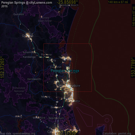
Analysis of Peregian Springs night lights 2016
Square area 10x10 km:
 0.57%
0.57%90-99
0.76%80-89
0.57%70-79
0%60-69
8.14%50-59
2.65%40-49
2.84%30-39
2.84%20-29
1.33%10-19
5.3%0-9
75%Square area 50x50 km:
0.46%90-99
0.63%80-89
0.36%70-79
0.29%60-69
3.02%50-59
0.86%40-49
1.16%30-39
1.17%20-29
1.11%10-19
5.1%0-9
85.83%Clear (daylight) street map image can be seen on geolist.org.
Map coordinates:
25° 51' 25.1" South, 152° 22' 21.5" East
26° 29' 16.8" South, 153° 4' 32.8" East
27° 6' 56.1" South, 153° 46' 44" East
Some cities around Peregian Springs sort by population:
• Buderim
21.9 km =13.6 mi,  184°
184°
• Maroochydore
19.3 km =12 mi,  172°
172°
• Nambour
19.2 km =11.9 mi,  217°
217°
• Tewantin
11.5 km =7.1 mi,  339°
339°
• Noosaville
9.8 km =6.1 mi,  354°
354°
• Coolum Beach
4.6 km =2.9 mi,  164°
164°
• Bli Bli
14.9 km =9.3 mi,  195°
195°
• Noosa Heads
10.5 km =6.5 mi,  7°
7°
10104370 (p: 6,887)
Sources (retrieved 2019-11-25):
» Earth at Night: Flat Maps 2012, 2016