Coolum Beach night lights from space
Night Light of Coolum Beach (Queensland) from space (Australia) Src. Average luminocity for 10x10km area is 18.3333% and for 50x50km: 7.8277%.
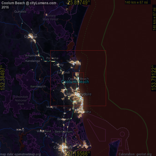
Analysis of Coolum Beach night lights 2016
Square area 10x10 km:
 0.76%
0.76%90-99
0.95%80-89
0.57%70-79
0%60-69
9.85%50-59
3.79%40-49
4.73%30-39
2.08%20-29
1.33%10-19
5.11%0-9
70.83%Square area 50x50 km:
0.61%90-99
0.73%80-89
0.42%70-79
0.32%60-69
3.36%50-59
1.02%40-49
1.34%30-39
1.37%20-29
1.64%10-19
5.81%0-9
83.37%Clear (daylight) street map image can be seen on geolist.org.
Map coordinates:
25° 53' 51" South, 152° 23' 5.9" East
26° 31' 41.9" South, 153° 5' 17.1" East
27° 9' 20.4" South, 153° 47' 28.4" East
Some cities around Coolum Beach sort by population:
• Maroochydore
14.7 km =9.1 mi,  175°
175°
• Nambour
16.8 km =10.4 mi,  229°
229°
• Tewantin
16.2 km =10.1 mi,  340°
340°
• Noosaville
14.4 km =8.9 mi,  351°
351°
• Mooloolaba
17.3 km =10.7 mi,  169°
169°
• Bli Bli
11.1 km =6.9 mi,  207°
207°
• Noosa Heads
14.9 km =9.3 mi,  0°
0°
• Peregian Springs
4.6 km =2.9 mi, 344°
2170581 (p: 9,346)
Sources (retrieved 2019-11-25):
» Earth at Night: Flat Maps 2012, 2016