Peakhurst night lights from space
Night Light of Peakhurst (New South Wales) from space (Australia) Src. Average luminocity for 10x10km area is 78.3252% and for 50x50km: 50.3453%.
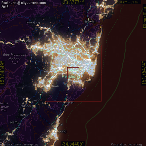
Analysis of Peakhurst night lights 2016
Square area 10x10 km:
 17.13%
90-99
23.95%80-89
10.66%70-79
9.44%60-69
17.66%50-59
13.99%40-49
3.5%30-39
2.8%20-29
0.87%10-19
0%0-9
0%Square area 50x50 km:
12.53%90-99
13.75%80-89
6.96%70-79
7.91%60-69
8.1%50-59
4.34%40-49
2.94%30-39
3.93%20-29
4.57%10-19
6.7%0-9
28.26%Clear (daylight) street map image can be seen on geolist.org.
Map coordinates:
33° 22' 39.8" South, 150° 20' 54.6" East
33° 57' 46.4" South, 151° 3' 5.8" East
34° 32' 38.6" South, 151° 45' 17.1" East
Some cities around Peakhurst sort by population:
• Padstow
1.9 km =1.2 mi,  290°
290°
• Penshurst
3 km =1.9 mi,  98°
98°
• Riverwood
1.7 km =1.1 mi,  354°
354°
• Mortdale
2 km =1.2 mi,  109°
109°
• Oatley
2.7 km =1.7 mi,  135°
135°
• Beverly Hills
3.1 km =1.9 mi,  57°
57°
• Narwee
2.4 km =1.5 mi,  41°
41°
• Lugarno
2.4 km =1.5 mi,  202°
202°
2206007 (p: 10,450)
Sources (retrieved 2019-11-25):
» Earth at Night: Flat Maps 2012, 2016