Penshurst night lights from space
Night Light of Penshurst (New South Wales) from space (Australia) Src. Average luminocity for 10x10km area is 81.8304% and for 50x50km: 47.3504%.
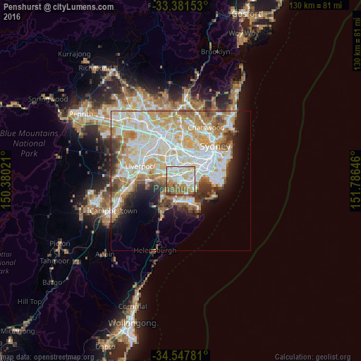
Analysis of Penshurst night lights 2016
Square area 10x10 km:
 19.41%
90-99
26.22%80-89
14.34%70-79
8.39%60-69
16.43%50-59
12.06%40-49
2.45%30-39
0.7%20-29
0%10-19
0%0-9
0%Square area 50x50 km:
12.12%90-99
13.25%80-89
6.63%70-79
7.4%60-69
7.22%50-59
3.9%40-49
2.45%30-39
3.33%20-29
3.82%10-19
6.24%0-9
33.64%Clear (daylight) street map image can be seen on geolist.org.
Map coordinates:
33° 22' 53.5" South, 150° 22' 48.8" East
33° 58' 0" South, 151° 4' 60" East
34° 32' 52.1" South, 151° 47' 11.3" East
Some cities around Penshurst sort by population:
• Hurstville
1.7 km =1.1 mi,  93°
93°
• Peakhurst
3 km =1.9 mi,  278°
278°
• Mortdale
1 km =0.6 mi,  255°
255°
• Oatley
1.8 km =1.1 mi,  215°
215°
• Beverly Hills
2.1 km =1.3 mi,  351°
351°
• Allawah
2.9 km =1.8 mi,  102°
102°
• Narwee
2.6 km =1.6 mi,  329°
329°
• South Hurstville
2.4 km =1.5 mi,  120°
120°
2153467 (p: 12,673)
Sources (retrieved 2019-11-25):
» Earth at Night: Flat Maps 2012, 2016