Palm Beach night lights from space
Night Light of Palm Beach (Queensland) from space (Australia) Src. Average luminocity for 10x10km area is 49.0379% and for 50x50km: 13.8534%.
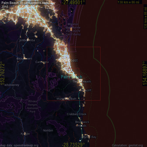
Analysis of Palm Beach night lights 2016
Square area 10x10 km:
 9.66%
9.66%90-99
10.23%80-89
6.06%70-79
1.52%60-69
15.34%50-59
3.98%40-49
4.92%30-39
3.98%20-29
17.05%10-19
21.97%0-9
5.3%Square area 50x50 km:
2.6%90-99
2.67%80-89
1.24%70-79
1.05%60-69
3.51%50-59
1.56%40-49
1.61%30-39
1.69%20-29
3.45%10-19
7.33%0-9
73.3%Clear (daylight) street map image can be seen on geolist.org.
Map coordinates:
27° 29' 42" South, 152° 45' 45.8" East
28° 7' 1" South, 153° 27' 57" East
28° 44' 7" South, 154° 10' 8.3" East
Some cities around Palm Beach sort by population:
• Varsity Lakes
6.1 km =3.8 mi,  300°
300°
• Burleigh Waters
4.5 km =2.8 mi, 295°
• Elanora
2.6 km =1.6 mi,  217°
217°
• Burleigh Heads
2.4 km =1.5 mi,  320°
320°
• Currumbin Waters
4.2 km =2.6 mi,  170°
170°
• Miami
5.6 km =3.5 mi,  334°
334°
• Tugun
5 km =3.1 mi,  137°
137°
• Reedy Creek
6.8 km =4.2 mi,  274°
274°
2153925 (p: 15,205)
Sources (retrieved 2019-11-25):
» Earth at Night: Flat Maps 2012, 2016