Burleigh Waters night lights from space
Night Light of Burleigh Waters (Queensland) from space (Australia) Src. Average luminocity for 10x10km area is 63.8939% and for 50x50km: 14.4702%.
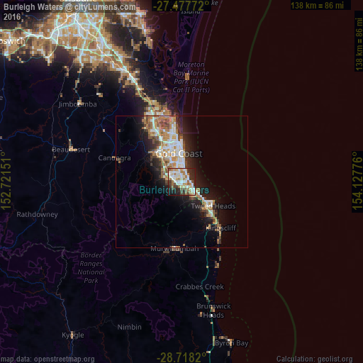
Analysis of Burleigh Waters night lights 2016
Square area 10x10 km:
 17.99%
90-99
14.58%80-89
7.2%70-79
3.03%60-69
16.1%50-59
5.3%40-49
7.01%30-39
6.63%20-29
14.77%10-19
7.2%0-9
0.19%Square area 50x50 km:
2.63%90-99
2.74%80-89
1.35%70-79
1.12%60-69
3.89%50-59
1.62%40-49
1.65%30-39
1.7%20-29
3.47%10-19
7.63%0-9
72.19%Clear (daylight) street map image can be seen on geolist.org.
Map coordinates:
27° 28' 39.8" South, 152° 43' 17.4" East
28° 5' 59.1" South, 153° 25' 28.7" East
28° 43' 5.5" South, 154° 7' 39.9" East
Some cities around Burleigh Waters sort by population:
• Robina
4.5 km =2.8 mi,  316°
316°
• Palm Beach
4.5 km =2.8 mi,  115°
115°
• Varsity Lakes
1.7 km =1.1 mi,  313°
313°
• Mudgeeraba
6 km =3.7 mi,  287°
287°
• Elanora
4.7 km =2.9 mi,  148°
148°
• Mermaid Waters
5.7 km =3.5 mi,  6°
6°
• Miami
3.5 km =2.2 mi,  28°
28°
• Reedy Creek
3.1 km =1.9 mi,  243°
243°
10063050 (p: 14,117)
Sources (retrieved 2019-11-25):
» Earth at Night: Flat Maps 2012, 2016