Tugun night lights from space
Night Light of Tugun (Queensland) from space (Australia) Src. Average luminocity for 10x10km area is 41.0833% and for 50x50km: 12.4608%.
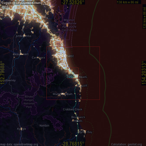
Analysis of Tugun night lights 2016
Square area 10x10 km:
 7.95%
7.95%90-99
7.58%80-89
4.73%70-79
1.7%60-69
14.02%50-59
1.89%40-49
2.08%30-39
2.27%20-29
13.45%10-19
34.09%0-9
10.23%Square area 50x50 km:
2.46%90-99
2.44%80-89
1.12%70-79
0.94%60-69
2.95%50-59
1.24%40-49
1.28%30-39
1.63%20-29
3.26%10-19
6.76%0-9
75.93%Clear (daylight) street map image can be seen on geolist.org.
Map coordinates:
27° 31' 41.7" South, 152° 47' 48.8" East
28° 9' 0" South, 153° 30' 0" East
28° 46' 5.3" South, 154° 12' 11.3" East
Some cities around Tugun sort by population:
• Palm Beach
5 km =3.1 mi,  317°
317°
• Elanora
5.2 km =3.2 mi,  287°
287°
• Burleigh Heads
7.4 km =4.6 mi, 318°
• Currumbin Waters
2.7 km =1.7 mi,  259°
259°
• Tweed Heads
5.3 km =3.3 mi,  123°
123°
• Coolangatta
4 km =2.5 mi, 122°
• Tweed Heads South
6.3 km =3.9 mi,  142°
142°
• Tweed Heads West
4.7 km =2.9 mi,  151°
151°
2145929 (p: 6,951)
Sources (retrieved 2019-11-25):
» Earth at Night: Flat Maps 2012, 2016