Mullaloo night lights from space
Night Light of Mullaloo (Western Australia) from space (Australia) Src. Average luminocity for 10x10km area is 54.7582% and for 50x50km: 26.9565%.
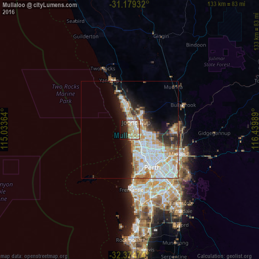
Analysis of Mullaloo night lights 2016
Square area 10x10 km:
 10.26%
90-99
10.62%80-89
8.79%70-79
11.36%60-69
12.82%50-59
4.95%40-49
1.47%30-39
1.47%20-29
12.45%10-19
16.67%0-9
9.16%Square area 50x50 km:
7.08%90-99
7.1%80-89
2.76%70-79
3.6%60-69
4.26%50-59
2.15%40-49
1.58%30-39
2.27%20-29
4.45%10-19
6.87%0-9
57.88%Clear (daylight) street map image can be seen on geolist.org.
Map coordinates:
31° 10' 45.6" South, 115° 2' 1.1" East
31° 46' 44.3" South, 115° 44' 12.3" East
32° 22' 29.1" South, 116° 26' 23.6" East
Some cities around Mullaloo sort by population:
• Hillarys
3.1 km =1.9 mi,  173°
173°
• Joondalup
4.9 km =3 mi,  37°
37°
• Padbury
4.3 km =2.7 mi,  135°
135°
• Ocean Reef
2.3 km =1.4 mi,  358°
358°
• Heathridge
2.8 km =1.7 mi,  48°
48°
• Craigie
3.3 km =2.1 mi,  106°
106°
• Iluka
4.9 km =3 mi,  353°
353°
• Kallaroo
2 km =1.2 mi,  131°
131°
2079189 (p: 5,794)
Sources (retrieved 2019-11-25):
» Earth at Night: Flat Maps 2012, 2016