Mount Colah night lights from space
Night Light of Mount Colah (New South Wales) from space (Australia) Src. Average luminocity for 10x10km area is 37.6685% and for 50x50km: 36.9945%.
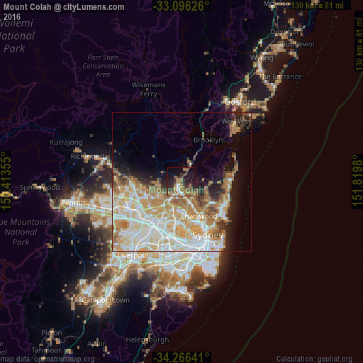
Analysis of Mount Colah night lights 2016
Square area 10x10 km:
 3.66%
3.66%90-99
3.48%80-89
0.92%70-79
6.04%60-69
14.65%50-59
6.04%40-49
3.85%30-39
9.16%20-29
14.65%10-19
24.91%0-9
12.64%Square area 50x50 km:
8.24%90-99
9.21%80-89
5.18%70-79
6.64%60-69
7.1%50-59
3.02%40-49
1.96%30-39
2.6%20-29
3.75%10-19
7.17%0-9
45.13%Clear (daylight) street map image can be seen on geolist.org.
Map coordinates:
33° 5' 46.5" South, 150° 24' 48.8" East
33° 40' 60" South, 151° 7' 0" East
34° 15' 59.1" South, 151° 49' 11.3" East
Some cities around Mount Colah sort by population:
• Hornsby
2.7 km =1.7 mi,  217°
217°
• Wahroonga
3.9 km =2.4 mi,  181°
181°
• Saint Ives
6.5 km =4 mi,  142°
142°
• Turramurra
5.7 km =3.5 mi,  168°
168°
• Thornleigh
6.5 km =4 mi,  212°
212°
• Hornsby Heights
2.5 km =1.6 mi,  302°
302°
• Waitara
3.3 km =2.1 mi,  201°
201°
• Normanhurst
4.9 km =3 mi, 203°
2156694 (p: 6,974)
Sources (retrieved 2019-11-25):
» Earth at Night: Flat Maps 2012, 2016