Modbury night lights from space
Night Light of Modbury (South Australia) from space (Australia) Src. Average luminocity for 10x10km area is 77.2106% and for 50x50km: 26.6779%.
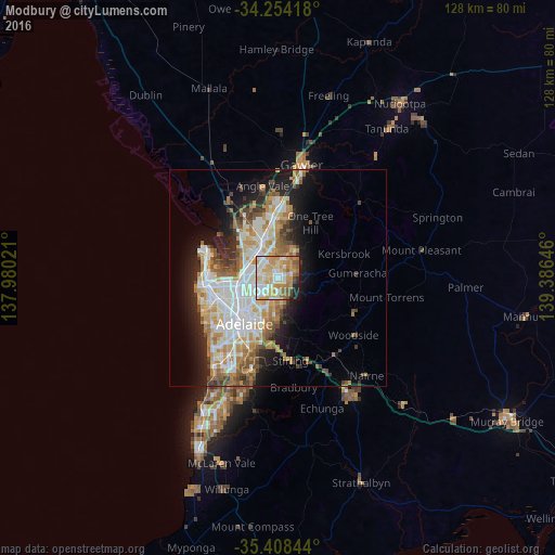
Analysis of Modbury night lights 2016
Square area 10x10 km:
 17.77%
90-99
17.4%80-89
14.84%70-79
21.25%60-69
11.72%50-59
7.14%40-49
2.56%30-39
1.1%20-29
4.21%10-19
2.01%0-9
0%Square area 50x50 km:
5.75%90-99
6.12%80-89
2.84%70-79
4.79%60-69
3.87%50-59
3.24%40-49
2.31%30-39
2.28%20-29
4.63%10-19
8.64%0-9
55.54%Clear (daylight) street map image can be seen on geolist.org.
Map coordinates:
34° 15' 15" South, 137° 58' 48.8" East
34° 49' 60" South, 138° 40' 60" East
35° 24' 30.4" South, 139° 23' 11.3" East
Some cities around Modbury sort by population:
• Athelstone
4.4 km =2.7 mi,  159°
159°
• Ingle Farm
4.6 km =2.9 mi,  270°
270°
• Hope Valley
1.5 km =0.9 mi,  90°
90°
• Wynn Vale
3.8 km =2.4 mi,  5°
5°
• Para Hills
3.3 km =2.1 mi,  315°
315°
• Highbury
2.5 km =1.6 mi,  149°
149°
• Valley View
2.2 km =1.4 mi,  250°
250°
• Redwood Park
3.2 km =2 mi,  41°
41°
2066041 (p: 5,306)
Sources (retrieved 2019-11-25):
» Earth at Night: Flat Maps 2012, 2016