Highbury night lights from space
Night Light of Highbury (South Australia) from space (Australia) Src. Average luminocity for 10x10km area is 60.3059% and for 50x50km: 27.1876%.
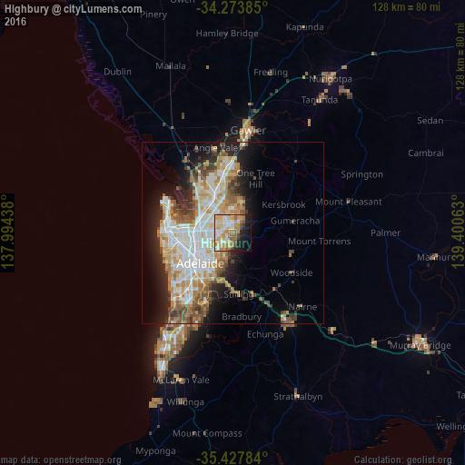
Analysis of Highbury night lights 2016
Square area 10x10 km:
 9.34%
9.34%90-99
11.17%80-89
13%70-79
16.3%60-69
11.17%50-59
6.04%40-49
3.3%30-39
1.83%20-29
9.16%10-19
13.92%0-9
4.76%Square area 50x50 km:
5.78%90-99
6.11%80-89
2.82%70-79
4.83%60-69
3.99%50-59
3.44%40-49
2.67%30-39
2.52%20-29
4.76%10-19
8.56%0-9
54.5%Clear (daylight) street map image can be seen on geolist.org.
Map coordinates:
34° 16' 25.9" South, 137° 59' 39.8" East
34° 51' 10.3" South, 138° 41' 51" East
35° 25' 40.2" South, 139° 24' 2.3" East
Some cities around Highbury sort by population:
• Athelstone
1.9 km =1.2 mi,  173°
173°
• Hope Valley
2.2 km =1.4 mi,  5°
5°
• Campbelltown
4.4 km =2.7 mi,  219°
219°
• Rostrevor
4.6 km =2.9 mi,  186°
186°
• Paradise
3.5 km =2.2 mi,  228°
228°
• Valley View
3.7 km =2.3 mi,  293°
293°
• Modbury North
3.5 km =2.2 mi,  321°
321°
• Modbury
2.5 km =1.6 mi,  329°
329°
8348147 (p: 6,432)
Sources (retrieved 2019-11-25):
» Earth at Night: Flat Maps 2012, 2016