Highett night lights from space
Night Light of Highett (Victoria) from space (Australia) Src. Average luminocity for 10x10km area is 76.5909% and for 50x50km: 49.4426%.
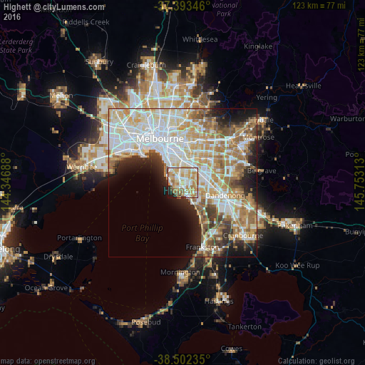
Analysis of Highett night lights 2016
Square area 10x10 km:
 16.56%
90-99
21.27%80-89
9.74%70-79
21.92%60-69
12.82%50-59
6.98%40-49
2.44%30-39
0.65%20-29
4.22%10-19
3.41%0-9
0%Square area 50x50 km:
13.39%90-99
12.03%80-89
6.17%70-79
7.9%60-69
7.34%50-59
5.83%40-49
3.7%30-39
3.47%20-29
5.13%10-19
6.97%0-9
28.07%Clear (daylight) street map image can be seen on geolist.org.
Map coordinates:
37° 23' 36.5" South, 144° 20' 48.8" East
37° 57' 0" South, 145° 3' 0" East
38° 30' 8.5" South, 145° 45' 11.3" East
Some cities around Highett sort by population:
• Bentleigh East
3.4 km =2.1 mi,  4°
4°
• Cheltenham
2.2 km =1.4 mi,  184°
184°
• Bentleigh
3.8 km =2.4 mi,  340°
340°
• Mentone
4 km =2.5 mi,  158°
158°
• Sandringham
3.4 km =2.1 mi,  265°
265°
• Black Rock
3.9 km =2.4 mi,  228°
228°
• Moorabbin
1.2 km =0.7 mi,  35°
35°
• McKinnon
3.7 km =2.3 mi, 0°
2163472 (p: 10,344)
Sources (retrieved 2019-11-25):
» Earth at Night: Flat Maps 2012, 2016