Long Jetty night lights from space
Night Light of Long Jetty (New South Wales) from space (Australia) Src. Average luminocity for 10x10km area is 22.4615% and for 50x50km: 8.1959%.
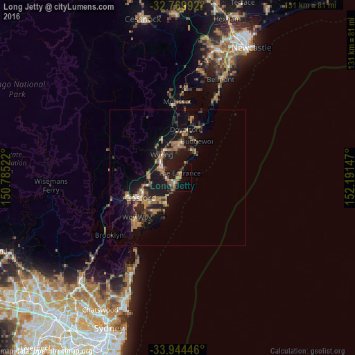
Analysis of Long Jetty night lights 2016
Square area 10x10 km:
 0.7%
0.7%90-99
1.4%80-89
0.17%70-79
4.37%60-69
5.94%50-59
6.99%40-49
2.62%30-39
3.32%20-29
2.97%10-19
33.04%0-9
38.46%Square area 50x50 km:
0.36%90-99
0.39%80-89
0.37%70-79
1.19%60-69
2.37%50-59
1.77%40-49
0.99%30-39
1.74%20-29
2.11%10-19
10.01%0-9
78.7%Clear (daylight) street map image can be seen on geolist.org.
Map coordinates:
32° 46' 11.7" South, 150° 47' 6.8" East
33° 21' 33" South, 151° 29' 18" East
33° 56' 40.1" South, 152° 11' 29.3" East
Some cities around Long Jetty sort by population:
• Bateau Bay
3.4 km =2.1 mi,  216°
216°
• Terrigal
10.6 km =6.6 mi,  201°
201°
• Gorokan
11.5 km =7.1 mi,  9°
9°
• Berkeley Vale
5.2 km =3.2 mi,  281°
281°
• Killarney Vale
2.9 km =1.8 mi,  260°
260°
• Wamberal
7.4 km =4.6 mi,  212°
212°
• Hamlyn Terrace
12.1 km =7.5 mi,  354°
354°
• Lisarow
11.6 km =7.2 mi, 256°
2159654 (p: 6,399)
Sources (retrieved 2019-11-25):
» Earth at Night: Flat Maps 2012, 2016