Berkeley Vale night lights from space
Night Light of Berkeley Vale (New South Wales) from space (Australia) Src. Average luminocity for 10x10km area is 29.8024% and for 50x50km: 8.3508%.
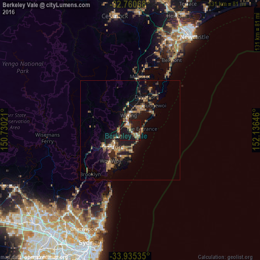
Analysis of Berkeley Vale night lights 2016
Square area 10x10 km:
 1.92%
1.92%90-99
2.97%80-89
0.17%70-79
4.55%60-69
8.22%50-59
5.94%40-49
2.8%30-39
3.5%20-29
4.55%10-19
65.21%0-9
0.17%Square area 50x50 km:
0.36%90-99
0.39%80-89
0.37%70-79
1.2%60-69
2.41%50-59
1.87%40-49
1.02%30-39
1.78%20-29
2.17%10-19
9.99%0-9
78.45%Clear (daylight) street map image can be seen on geolist.org.
Map coordinates:
32° 45' 38.4" South, 150° 43' 48.8" East
33° 21' 0" South, 151° 25' 60" East
33° 56' 7.3" South, 152° 8' 11.3" East
Some cities around Berkeley Vale sort by population:
• Bateau Bay
4.8 km =3 mi,  140°
140°
• Terrigal
11 km =6.8 mi,  173°
173°
• Wyoming
8.9 km =5.5 mi,  227°
227°
• Narara
10.4 km =6.5 mi,  240°
240°
• Killarney Vale
2.7 km =1.7 mi,  122°
122°
• Long Jetty
5.2 km =3.2 mi,  101°
101°
• Wamberal
7.4 km =4.6 mi, 171°
• Lisarow
7.2 km =4.5 mi, 239°
2176088 (p: 8,198)
Sources (retrieved 2019-11-25):
» Earth at Night: Flat Maps 2012, 2016