Gorokan night lights from space
Night Light of Gorokan (New South Wales) from space (Australia) Src. Average luminocity for 10x10km area is 28.0944% and for 50x50km: 8.655%.
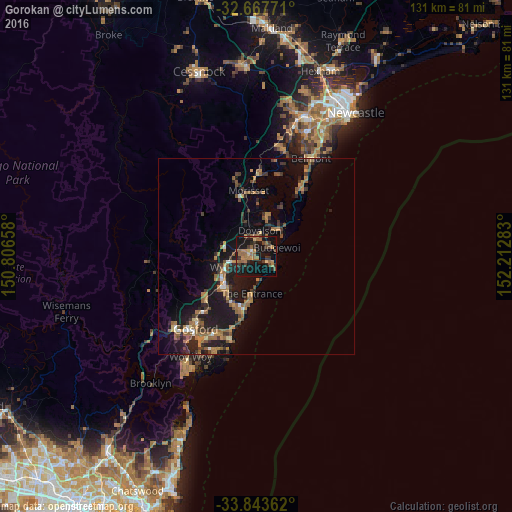
Analysis of Gorokan night lights 2016
Square area 10x10 km:
 0.52%
0.52%90-99
0.17%80-89
2.1%70-79
4.2%60-69
10.31%50-59
6.64%40-49
4.37%30-39
6.47%20-29
4.55%10-19
43.36%0-9
17.31%Square area 50x50 km:
0.36%90-99
0.41%80-89
0.4%70-79
1.25%60-69
2.37%50-59
1.92%40-49
1.14%30-39
1.88%20-29
2.15%10-19
10.04%0-9
78.08%Clear (daylight) street map image can be seen on geolist.org.
Map coordinates:
32° 40' 3.8" South, 150° 48' 23.7" East
33° 15' 27.5" South, 151° 30' 34.9" East
33° 50' 37" South, 152° 12' 46.2" East
Some cities around Gorokan sort by population:
• Bateau Bay
14.5 km =9 mi,  195°
195°
• Berkeley Vale
12.5 km =7.8 mi,  214°
214°
• Killarney Vale
12.7 km =7.9 mi, 202°
• Long Jetty
11.5 km =7.1 mi,  189°
189°
• Blue Haven
5.2 km =3.2 mi,  353°
353°
• Hamlyn Terrace
3.2 km =2 mi,  282°
282°
• Woongarrah
3.6 km =2.2 mi,  299°
299°
• Lake Munmorah
9.5 km =5.9 mi,  45°
45°
2164855 (p: 8,211)
Sources (retrieved 2019-11-25):
» Earth at Night: Flat Maps 2012, 2016