Wamberal night lights from space
Night Light of Wamberal (New South Wales) from space (Australia) Src. Average luminocity for 10x10km area is 26.4563% and for 50x50km: 8.1528%.
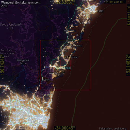
Analysis of Wamberal night lights 2016
Square area 10x10 km:
 0.52%
0.52%90-99
1.22%80-89
1.05%70-79
5.59%60-69
6.82%50-59
8.39%40-49
2.97%30-39
3.5%20-29
2.62%10-19
45.63%0-9
21.68%Square area 50x50 km:
0.36%90-99
0.39%80-89
0.37%70-79
1.15%60-69
2.49%50-59
1.81%40-49
1.02%30-39
1.61%20-29
2.04%10-19
9.85%0-9
78.92%Clear (daylight) street map image can be seen on geolist.org.
Map coordinates:
32° 49' 36" South, 150° 44' 32.9" East
33° 24' 55.9" South, 151° 26' 44.1" East
34° 0' 1.6" South, 152° 8' 55.4" East
Some cities around Wamberal sort by population:
• Bateau Bay
4.1 km =2.5 mi,  28°
28°
• Terrigal
3.6 km =2.2 mi,  178°
178°
• Wyoming
7.8 km =4.8 mi,  279°
279°
• Berkeley Vale
7.4 km =4.6 mi,  351°
351°
• Narara
10.5 km =6.5 mi, 282°
• Killarney Vale
5.9 km =3.7 mi,  11°
11°
• Long Jetty
7.4 km =4.6 mi, 32°
• Lisarow
8.2 km =5.1 mi,  296°
296°
2144838 (p: 6,378)
Sources (retrieved 2019-11-25):
» Earth at Night: Flat Maps 2012, 2016