Lisarow night lights from space
Night Light of Lisarow (New South Wales) from space (Australia) Src. Average luminocity for 10x10km area is 28.8094% and for 50x50km: 8.2986%.
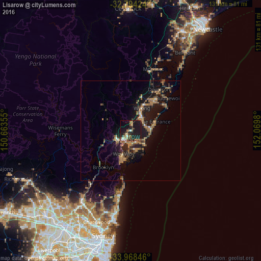
Analysis of Lisarow night lights 2016
Square area 10x10 km:
 2.62%
2.62%90-99
2.27%80-89
2.8%70-79
0.87%60-69
8.57%50-59
5.24%40-49
2.1%30-39
5.59%20-29
8.39%10-19
47.73%0-9
13.81%Square area 50x50 km:
0.36%90-99
0.39%80-89
0.37%70-79
1.19%60-69
2.46%50-59
1.83%40-49
1.04%30-39
1.77%20-29
2.12%10-19
9.95%0-9
78.52%Clear (daylight) street map image can be seen on geolist.org.
Map coordinates:
32° 47' 39.3" South, 150° 39' 48.8" East
33° 22' 60" South, 151° 22' 0" East
33° 58' 6.5" South, 152° 4' 11.3" East
Some cities around Lisarow sort by population:
• Bateau Bay
9.3 km =5.8 mi,  90°
90°
• Terrigal
10.3 km =6.4 mi,  134°
134°
• Wyoming
2.3 km =1.4 mi,  189°
189°
• Berkeley Vale
7.2 km =4.5 mi,  59°
59°
• Narara
3.2 km =2 mi,  244°
244°
• Killarney Vale
8.8 km =5.5 mi,  75°
75°
• Wamberal
8.2 km =5.1 mi,  116°
116°
• Kariong
9.2 km =5.7 mi,  226°
226°
2160070 (p: 5,036)
Sources (retrieved 2019-11-25):
» Earth at Night: Flat Maps 2012, 2016