Lawnton night lights from space
Night Light of Lawnton (Queensland) from space (Australia) Src. Average luminocity for 10x10km area is 65.7121% and for 50x50km: 28.2613%.
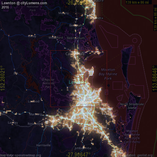
Analysis of Lawnton night lights 2016
Square area 10x10 km:
 12.5%
12.5%90-99
9.28%80-89
8.14%70-79
7.39%60-69
29.17%50-59
11.17%40-49
5.49%30-39
5.87%20-29
7.39%10-19
3.6%0-9
0%Square area 50x50 km:
5.56%90-99
6.11%80-89
3.51%70-79
2.81%60-69
7.4%50-59
2.38%40-49
3.1%30-39
3.2%20-29
4.9%10-19
8.88%0-9
52.15%Clear (daylight) street map image can be seen on geolist.org.
Map coordinates:
26° 39' 24" South, 152° 16' 48.8" East
27° 16' 60" South, 152° 58' 60" East
27° 54' 23.3" South, 153° 41' 11.3" East
Some cities around Lawnton sort by population:
• Kallangur
3.6 km =2.2 mi,  14°
14°
• Warner
4.6 km =2.9 mi,  225°
225°
• Murrumba Downs
3.2 km =2 mi,  56°
56°
• Bray Park
1.8 km =1.1 mi,  236°
236°
• Strathpine
2.4 km =1.5 mi,  164°
164°
• Petrie
1.9 km =1.2 mi,  0°
0°
• Griffin
5.7 km =3.5 mi,  76°
76°
• Bald Hills
4.9 km =3 mi,  149°
149°
2160484 (p: 5,560)
Sources (retrieved 2019-11-25):
» Earth at Night: Flat Maps 2012, 2016