The Gap night lights from space
Night Light of The Gap (Queensland) from space (Australia) Src. Average luminocity for 10x10km area is 49.822% and for 50x50km: 42.9185%.
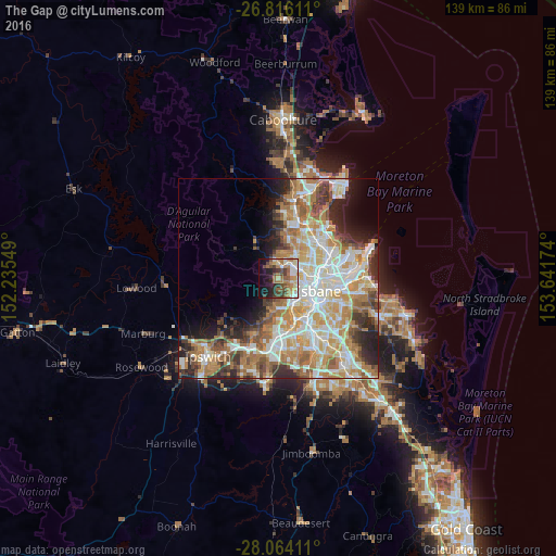
Analysis of The Gap night lights 2016
Square area 10x10 km:
 6.25%
6.25%90-99
8.52%80-89
6.82%70-79
4.17%60-69
17.05%50-59
6.25%40-49
10.23%30-39
5.68%20-29
8.71%10-19
18.37%0-9
7.95%Square area 50x50 km:
8.98%90-99
9.66%80-89
5.6%70-79
6.07%60-69
10.75%50-59
3.85%40-49
4.58%30-39
4.11%20-29
6.09%10-19
6.53%0-9
33.79%Clear (daylight) street map image can be seen on geolist.org.
Map coordinates:
26° 48' 58" South, 152° 14' 7.8" East
27° 26' 30.7" South, 152° 56' 19" East
28° 3' 50.8" South, 153° 38' 30.3" East
Some cities around The Gap sort by population:
• Ashgrove
5.3 km =3.3 mi,  94°
94°
• Bardon
4.5 km =2.8 mi,  117°
117°
• Ferny Hills
5.1 km =3.2 mi,  358°
358°
• Mitchelton
3.9 km =2.4 mi,  44°
44°
• Keperra
3.2 km =2 mi,  14°
14°
• Arana Hills
5.2 km =3.2 mi,  21°
21°
• Ferny Grove
4.6 km =2.9 mi, 355°
• Enoggera
3.9 km =2.4 mi,  67°
67°
6943585 (p: 16,371)
Sources (retrieved 2019-11-25):
» Earth at Night: Flat Maps 2012, 2016