Indooroopilly night lights from space
Night Light of Indooroopilly (Queensland) from space (Australia) Src. Average luminocity for 10x10km area is 77.4643% and for 50x50km: 45.7357%.
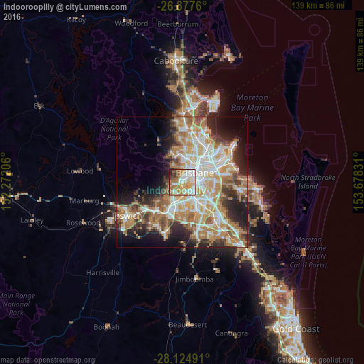
Analysis of Indooroopilly night lights 2016
Square area 10x10 km:
 18.25%
90-99
21.03%80-89
11.11%70-79
13.29%60-69
18.25%50-59
5.95%40-49
5.56%30-39
3.37%20-29
3.17%10-19
0%0-9
0%Square area 50x50 km:
9.04%90-99
9.79%80-89
5.77%70-79
6.5%60-69
12.21%50-59
4.07%40-49
4.86%30-39
4.4%20-29
7.65%10-19
9.41%0-9
26.3%Clear (daylight) street map image can be seen on geolist.org.
Map coordinates:
26° 52' 39.4" South, 152° 16' 19.4" East
27° 30' 10.9" South, 152° 58' 30.6" East
28° 7' 29.7" South, 153° 40' 41.9" East
Some cities around Indooroopilly sort by population:
• Toowong
2.3 km =1.4 mi,  20°
20°
• Chapel Hill
2.5 km =1.6 mi,  270°
270°
• West End
4.3 km =2.7 mi,  52°
52°
• Kenmore
3.6 km =2.2 mi,  261°
261°
• Taringa
1.4 km =0.9 mi,  13°
13°
• Yeronga
4.3 km =2.7 mi,  109°
109°
• Auchenflower
3.6 km =2.2 mi,  27°
27°
• Highgate Hill
4.6 km =2.9 mi,  70°
70°
6943573 (p: 11,987)
Sources (retrieved 2019-11-25):
» Earth at Night: Flat Maps 2012, 2016