Flinders night lights from space
Night Light of Flinders (New South Wales) from space (Australia) Src. Average luminocity for 10x10km area is 32.7517% and for 50x50km: 7.2581%.
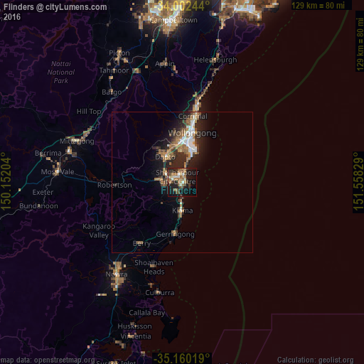
Analysis of Flinders night lights 2016
Square area 10x10 km:
 2.45%
2.45%90-99
3.5%80-89
3.5%70-79
3.5%60-69
9.44%50-59
6.12%40-49
5.24%30-39
6.12%20-29
8.74%10-19
31.82%0-9
19.58%Square area 50x50 km:
0.79%90-99
1.07%80-89
0.36%70-79
0.69%60-69
1.83%50-59
1.34%40-49
0.87%30-39
1.26%20-29
2.95%10-19
5.11%0-9
83.73%Clear (daylight) street map image can be seen on geolist.org.
Map coordinates:
34° 0' 8.8" South, 150° 9' 7.3" East
34° 34' 60" South, 150° 51' 18.6" East
35° 9' 36.7" South, 151° 33' 29.8" East
Some cities around Flinders sort by population:
• Albion Park
7.4 km =4.6 mi,  280°
280°
• Dapto
10.5 km =6.5 mi,  327°
327°
• Kiama
9.4 km =5.8 mi,  181°
181°
• Albion Park Rail
6.1 km =3.8 mi,  288°
288°
• Oak Flats
3.8 km =2.4 mi,  307°
307°
• Warilla
3.5 km =2.2 mi,  4°
4°
• Barrack Heights
2.1 km =1.3 mi, 4°
• Shell Cove
1 km =0.6 mi,  139°
139°
6255012 (p: 6,558)
Sources (retrieved 2019-11-25):
» Earth at Night: Flat Maps 2012, 2016