Oak Flats night lights from space
Night Light of Oak Flats (New South Wales) from space (Australia) Src. Average luminocity for 10x10km area is 41.9895% and for 50x50km: 7.5564%.
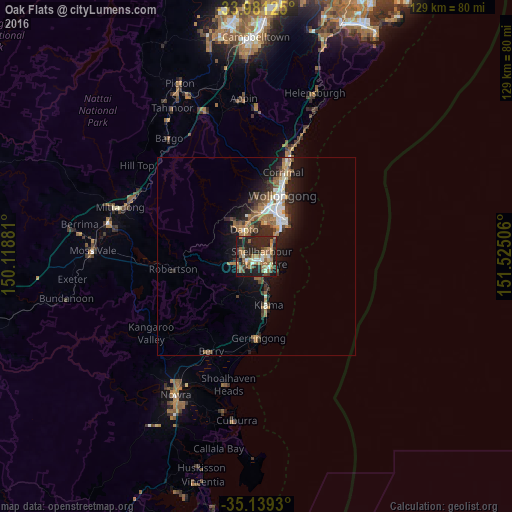
Analysis of Oak Flats night lights 2016
Square area 10x10 km:
 2.45%
2.45%90-99
4.55%80-89
3.5%70-79
4.72%60-69
14.69%50-59
8.39%40-49
5.42%30-39
8.04%20-29
25.87%10-19
21.85%0-9
0.52%Square area 50x50 km:
0.81%90-99
1.09%80-89
0.39%70-79
0.77%60-69
1.89%50-59
1.4%40-49
0.88%30-39
1.3%20-29
2.94%10-19
5.61%0-9
82.93%Clear (daylight) street map image can be seen on geolist.org.
Map coordinates:
33° 58' 52.5" South, 150° 7' 7.7" East
34° 33' 44.2" South, 150° 49' 18.9" East
35° 8' 21.5" South, 151° 31' 30.2" East
Some cities around Oak Flats sort by population:
• Albion Park
4.4 km =2.7 mi,  256°
256°
• Dapto
7 km =4.3 mi,  338°
338°
• Albion Park Rail
2.8 km =1.7 mi, 260°
• Flinders
3.8 km =2.4 mi,  127°
127°
• Warilla
3.5 km =2.2 mi,  70°
70°
• Barrack Heights
3.2 km =2 mi,  94°
94°
• Shell Cove
4.8 km =3 mi, 129°
• Kanahooka
8 km =5 mi,  350°
350°
8348722 (p: 6,427)
Sources (retrieved 2019-11-25):
» Earth at Night: Flat Maps 2012, 2016