Narrabeen night lights from space
Night Light of Narrabeen (New South Wales) from space (Australia) Src. Average luminocity for 10x10km area is 36.0952% and for 50x50km: 24.0006%.
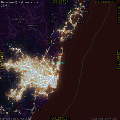
Analysis of Narrabeen night lights 2016
Square area 10x10 km:
 1.47%
1.47%90-99
5.31%80-89
2.75%70-79
4.76%60-69
13.19%50-59
6.04%40-49
2.38%30-39
8.24%20-29
12.27%10-19
28.94%0-9
14.65%Square area 50x50 km:
5.56%90-99
5.6%80-89
2.82%70-79
3.92%60-69
5.05%50-59
2.03%40-49
1.35%30-39
2.14%20-29
2.84%10-19
5.55%0-9
63.15%Clear (daylight) street map image can be seen on geolist.org.
Map coordinates:
33° 7' 33.2" South, 150° 35' 39.3" East
33° 42' 46" South, 151° 17' 50.5" East
34° 17' 44.3" South, 152° 0' 1.8" East
Some cities around Narrabeen sort by population:
• Dee Why
4.3 km =2.7 mi,  190°
190°
• Mona Vale
3.9 km =2.4 mi,  7°
7°
• Newport
6.5 km =4 mi, 13°
• Collaroy
2.2 km =1.4 mi,  170°
170°
• Cromer
3.4 km =2.1 mi,  233°
233°
• Beacon Hill
5.7 km =3.5 mi,  218°
218°
• Warriewood
2.7 km =1.7 mi,  356°
356°
• North Narrabeen
0.4 km =0.2 mi,  342°
342°
2155745 (p: 8,049)
Sources (retrieved 2019-11-25):
» Earth at Night: Flat Maps 2012, 2016