Como night lights from space
Night Light of Como (Western Australia) from space (Australia) Src. Average luminocity for 10x10km area is 86.3129% and for 50x50km: 42.6641%.
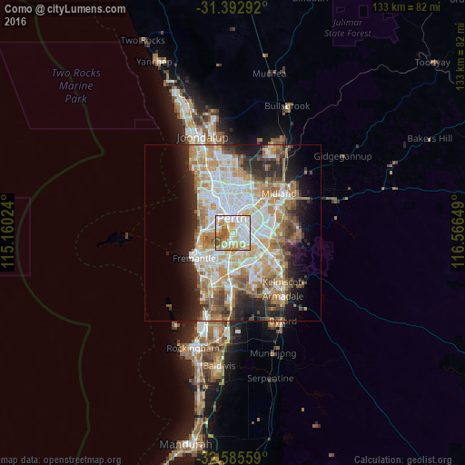
Analysis of Como night lights 2016
Square area 10x10 km:
 26.75%
90-99
28.32%80-89
13.99%70-79
16.26%60-69
6.12%50-59
5.07%40-49
3.5%30-39
0%20-29
0%10-19
0%0-9
0%Square area 50x50 km:
9.3%90-99
10.19%80-89
4.91%70-79
6.7%60-69
8.31%50-59
4.76%40-49
3.53%30-39
3.91%20-29
7%10-19
8.8%0-9
32.58%Clear (daylight) street map image can be seen on geolist.org.
Map coordinates:
31° 23' 34.5" South, 115° 9' 36.9" East
31° 59' 28.3" South, 115° 51' 48.1" East
32° 35' 8.1" South, 116° 33' 59.4" East
Some cities around Como sort by population:
• Perth
4.3 km =2.7 mi,  357°
357°
• Perth city centre
4.4 km =2.7 mi,  345°
345°
• South Perth
0.9 km =0.6 mi,  19°
19°
• East Perth
3.7 km =2.3 mi,  11°
11°
• East Victoria Park
3.8 km =2.4 mi,  86°
86°
• Victoria Park
4.3 km =2.7 mi,  67°
67°
• Applecross
4 km =2.5 mi,  224°
224°
• West Perth
5.1 km =3.2 mi,  336°
336°
6695266 (p: 13,965)
Sources (retrieved 2019-11-25):
» Earth at Night: Flat Maps 2012, 2016