Clifton Hill night lights from space
Night Light of Clifton Hill (Victoria) from space (Australia) Src. Average luminocity for 10x10km area is 96.7381% and for 50x50km: 56.2977%.
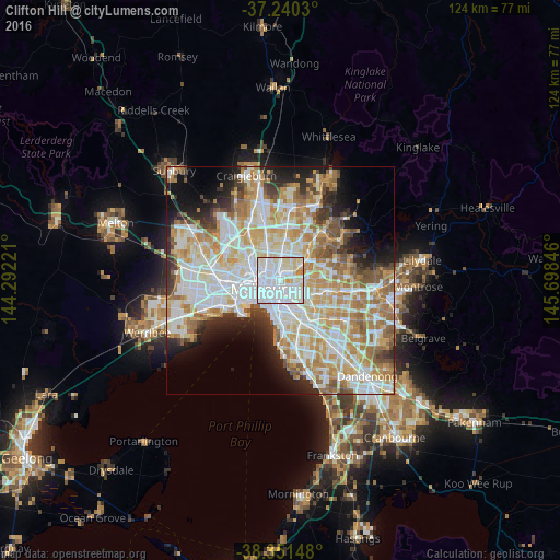
Analysis of Clifton Hill night lights 2016
Square area 10x10 km:
 59.86%
90-99
24.66%80-89
12.59%70-79
2.38%60-69
0.51%50-59
0%40-49
0%30-39
0%20-29
0%10-19
0%0-9
0%Square area 50x50 km:
15.52%90-99
14.28%80-89
7.12%70-79
9.7%60-69
8.24%50-59
5.19%40-49
3.71%30-39
3.29%20-29
5.43%10-19
7.51%0-9
20.01%Clear (daylight) street map image can be seen on geolist.org.
Map coordinates:
37° 14' 25.1" South, 144° 17' 32" East
37° 47' 52.7" South, 144° 59' 43.2" East
38° 21' 5.3" South, 145° 41' 54.5" East
Some cities around Clifton Hill sort by population:
• Richmond
2.3 km =1.4 mi,  165°
165°
• Carlton
2.5 km =1.6 mi,  264°
264°
• Fitzroy North
1.8 km =1.1 mi,  305°
305°
• Fitzroy
1.5 km =0.9 mi,  268°
268°
• Collingwood
0.8 km =0.5 mi,  228°
228°
• Abbotsford
0.5 km =0.3 mi,  118°
118°
• East Melbourne
2.2 km =1.4 mi,  197°
197°
• Carlton North
2.5 km =1.6 mi,  296°
296°
2171324 (p: 5,790)
Sources (retrieved 2019-11-25):
» Earth at Night: Flat Maps 2012, 2016