Brunswick East night lights from space
Night Light of Brunswick East (Victoria) from space (Australia) Src. Average luminocity for 10x10km area is 96.6786% and for 50x50km: 55.0268%.
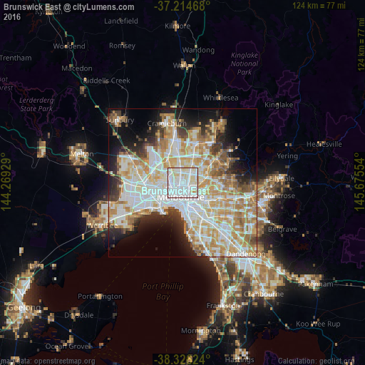
Analysis of Brunswick East night lights 2016
Square area 10x10 km:
 54.08%
90-99
28.06%80-89
17.01%70-79
0.85%60-69
0%50-59
0%40-49
0%30-39
0%20-29
0%10-19
0%0-9
0%Square area 50x50 km:
14.98%90-99
13.8%80-89
6.94%70-79
9.69%60-69
7.87%50-59
4.6%40-49
3.63%30-39
3.53%20-29
5.81%10-19
8.73%0-9
20.41%Clear (daylight) street map image can be seen on geolist.org.
Map coordinates:
37° 12' 52.8" South, 144° 16' 9.4" East
37° 46' 21.2" South, 144° 58' 20.7" East
38° 19' 34.5" South, 145° 40' 31.9" East
Some cities around Brunswick East sort by population:
• Coburg
2.6 km =1.6 mi,  348°
348°
• Northcote
2.5 km =1.6 mi,  74°
74°
• Carlton
3.1 km =1.9 mi,  189°
189°
• Thornbury
3.3 km =2.1 mi,  61°
61°
• Fitzroy North
1.9 km =1.2 mi,  162°
162°
• Fitzroy
2.9 km =1.8 mi,  169°
169°
• Parkville
2.3 km =1.4 mi,  238°
238°
• Carlton North
1.7 km =1.1 mi, 186°
2173739 (p: 11,315)
Sources (retrieved 2019-11-25):
» Earth at Night: Flat Maps 2012, 2016