Adamstown Heights night lights from space
Night Light of Adamstown Heights (New South Wales) from space (Australia) Src. Average luminocity for 10x10km area is 64.2326% and for 50x50km: 14.94%.
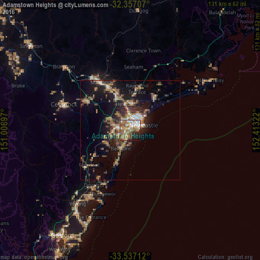
Analysis of Adamstown Heights night lights 2016
Square area 10x10 km:
 10.81%
90-99
13.19%80-89
5.31%70-79
11.9%60-69
23.44%50-59
11.54%40-49
4.58%30-39
2.75%20-29
9.52%10-19
6.41%0-9
0.55%Square area 50x50 km:
1.43%90-99
1.67%80-89
0.55%70-79
2.42%60-69
4.25%50-59
2.18%40-49
2.12%30-39
3.38%20-29
3.86%10-19
10.04%0-9
68.1%Clear (daylight) street map image can be seen on geolist.org.
Map coordinates:
32° 21' 25.5" South, 151° 0' 25.1" East
32° 56' 56.6" South, 151° 42' 36.3" East
33° 32' 13.6" South, 152° 24' 47.6" East
Some cities around Adamstown Heights sort by population:
• Newcastle
6.9 km =4.3 mi,  71°
71°
• Wallsend
6.8 km =4.2 mi,  321°
321°
• Charlestown
2.7 km =1.7 mi,  216°
216°
• Merewether
3.1 km =1.9 mi,  87°
87°
• New Lambton
2.3 km =1.4 mi,  356°
356°
• Mayfield
6.2 km =3.9 mi,  23°
23°
• Warners Bay
6 km =3.7 mi,  244°
244°
• Elermore Vale
4.8 km =3 mi, 319°
8347693 (p: 5,215)
Sources (retrieved 2019-11-25):
» Earth at Night: Flat Maps 2012, 2016