Wimpassing night lights from space
Night Light of Wimpassing (Upper Austria) from space (Austria) Src. Average luminocity for 10x10km area is 23.5744% and for 50x50km: 6.3451%.
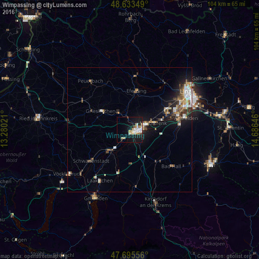
Analysis of Wimpassing night lights 2016
Square area 10x10 km:
 4.46%
4.46%90-99
5.51%80-89
2.83%70-79
2.23%60-69
3.42%50-59
1.34%40-49
0.74%30-39
0.3%20-29
2.53%10-19
29.46%0-9
47.17%Square area 50x50 km:
0.93%90-99
1.17%80-89
0.61%70-79
0.65%60-69
0.7%50-59
0.89%40-49
1.04%30-39
0.82%20-29
1.32%10-19
4.39%0-9
87.49%Clear (daylight) street map image can be seen on geolist.org.
Map coordinates:
48° 38' 0.6" North, 13° 16' 48.8" East
48° 10' 0" North, 13° 58' 60" East
47° 41' 44" North, 14° 41' 11.3" East
Some cities around Wimpassing sort by population:
• Wels
3.7 km =2.3 mi,  90°
90°
• Traun
19.8 km =12.3 mi,  72°
72°
• Marchtrenk
9.7 km =6 mi, 74°
• Vorchdorf
18.7 km =11.6 mi,  194°
194°
• Kremsmünster
16.7 km =10.4 mi,  139°
139°
• Neuhofen an der Krems
18.4 km =11.4 mi,  99°
99°
• Lichtenegg
2.2 km =1.4 mi,  146°
146°
• Oberhaid
2.6 km =1.6 mi, 66°
2761148 (p: 5,748)
Sources (retrieved 2019-11-25):
» Earth at Night: Flat Maps 2012, 2016