Marchtrenk night lights from space
Night Light of Marchtrenk (Upper Austria) from space (Austria) Src. Average luminocity for 10x10km area is 19.6667% and for 50x50km: 8.0153%.
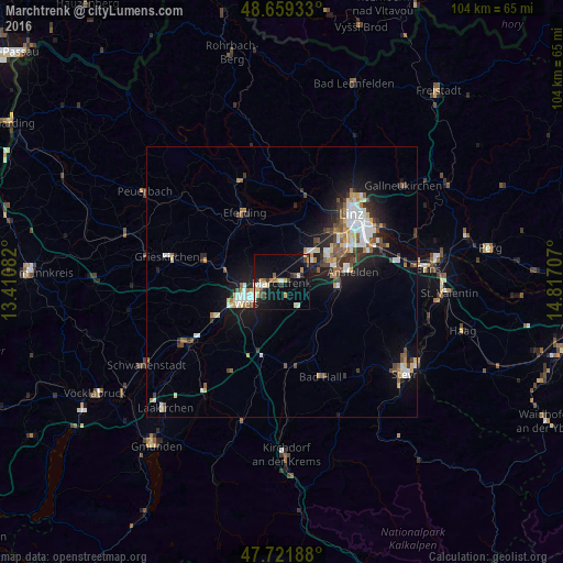
Analysis of Marchtrenk night lights 2016
Square area 10x10 km:
 1.79%
1.79%90-99
3.27%80-89
2.23%70-79
3.57%60-69
1.34%50-59
1.34%40-49
3.27%30-39
2.23%20-29
2.53%10-19
20.68%0-9
57.74%Square area 50x50 km:
1.25%90-99
1.52%80-89
0.77%70-79
0.78%60-69
0.81%50-59
1.02%40-49
1.11%30-39
1.06%20-29
1.82%10-19
5.8%0-9
84.07%Clear (daylight) street map image can be seen on geolist.org.
Map coordinates:
48° 39' 33.6" North, 13° 24' 39" East
48° 11' 24.8" North, 14° 6' 32.7" East
47° 43' 18.8" North, 14° 49' 1.5" East
Some cities around Marchtrenk sort by population:
• Wels
6.2 km =3.9 mi,  245°
245°
• Traun
10.2 km =6.3 mi,  70°
70°
• Haid
10.6 km =6.6 mi,  81°
81°
• Sankt Martin
12.6 km =7.8 mi, 68°
• Neuhofen an der Krems
10.5 km =6.5 mi,  123°
123°
• Lichtenegg
9.2 km =5.7 mi,  241°
241°
• Wimpassing
9.7 km =6 mi, 254°
• Oberhaid
7.2 km =4.5 mi,  257°
257°
2771962 (p: 8,394)
Sources (retrieved 2019-11-25):
» Earth at Night: Flat Maps 2012, 2016