Lichtenegg night lights from space
Night Light of Lichtenegg (Upper Austria) from space (Austria) Src. Average luminocity for 10x10km area is 27.2232% and for 50x50km: 6.8231%.
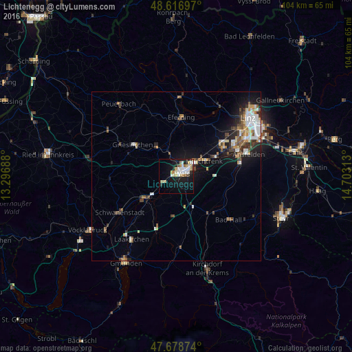
Analysis of Lichtenegg night lights 2016
Square area 10x10 km:
 5.51%
5.51%90-99
6.25%80-89
3.57%70-79
3.13%60-69
3.42%50-59
1.04%40-49
1.34%30-39
0.6%20-29
3.42%10-19
26.04%0-9
45.68%Square area 50x50 km:
1.11%90-99
1.32%80-89
0.63%70-79
0.67%60-69
0.72%50-59
0.93%40-49
1.02%30-39
0.87%20-29
1.47%10-19
4.63%0-9
86.63%Clear (daylight) street map image can be seen on geolist.org.
Map coordinates:
48° 37' 1.1" North, 13° 17' 48.8" East
48° 9' 0" North, 14° 0' 0" East
47° 40' 43.5" North, 14° 42' 11.3" East
Some cities around Lichtenegg sort by population:
• Wels
3.1 km =1.9 mi,  53°
53°
• Traun
19.3 km =12 mi,  65°
65°
• Marchtrenk
9.2 km =5.7 mi,  61°
61°
• Vorchdorf
17.3 km =10.7 mi,  199°
199°
• Kremsmünster
14.4 km =8.9 mi,  138°
138°
• Neuhofen an der Krems
16.9 km =10.5 mi,  94°
94°
• Wimpassing
2.2 km =1.4 mi,  326°
326°
• Oberhaid
3.1 km =1.9 mi,  21°
21°
2772537 (p: 6,163)
Sources (retrieved 2019-11-25):
» Earth at Night: Flat Maps 2012, 2016