Haid night lights from space
Night Light of Haid (Upper Austria) from space (Austria) Src. Average luminocity for 10x10km area is 30.6726% and for 50x50km: 8.5036%.
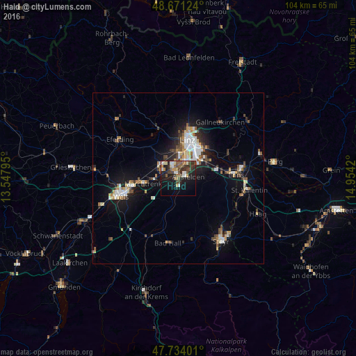
Analysis of Haid night lights 2016
Square area 10x10 km:
 2.38%
2.38%90-99
5.65%80-89
2.98%70-79
2.83%60-69
3.42%50-59
6.1%40-49
6.4%30-39
6.85%20-29
10.12%10-19
24.7%0-9
28.57%Square area 50x50 km:
1.24%90-99
1.53%80-89
0.83%70-79
0.85%60-69
0.86%50-59
1.08%40-49
1.26%30-39
1.17%20-29
1.83%10-19
6.23%0-9
83.11%Clear (daylight) street map image can be seen on geolist.org.
Map coordinates:
48° 40' 16.5" North, 13° 32' 52.6" East
48° 12' 17.2" North, 14° 15' 3.9" East
47° 44' 2.4" North, 14° 57' 15.1" East
Some cities around Haid sort by population:
• Linz
11.6 km =7.2 mi,  12°
12°
• Traun
2 km =1.2 mi,  332°
332°
• Enns
16.7 km =10.4 mi,  86°
86°
• Marchtrenk
10.6 km =6.6 mi,  261°
261°
• Sankt Martin
3.2 km =2 mi,  23°
23°
• Neuhofen an der Krems
7.6 km =4.7 mi,  193°
193°
• Hart
6.7 km =4.2 mi,  3°
3°
• Haag
7.4 km =4.6 mi, 10°
2777038 (p: 7,424)
Sources (retrieved 2019-11-25):
» Earth at Night: Flat Maps 2012, 2016