Kufstein night lights from space
Night Light of Kufstein (Tyrol) from space (Austria) Src. Average luminocity for 10x10km area is 9.7514% and for 50x50km: 2.027%.
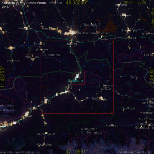
Analysis of Kufstein night lights 2016
Square area 10x10 km:
 2.98%
2.98%90-99
1.56%80-89
0%70-79
0%60-69
0.71%50-59
0.99%40-49
2.84%30-39
0.28%20-29
1.28%10-19
0.43%0-9
88.92%Square area 50x50 km:
0.31%90-99
0.28%80-89
0.13%70-79
0.13%60-69
0.2%50-59
0.26%40-49
0.38%30-39
0.38%20-29
0.52%10-19
0.32%0-9
97.09%Clear (daylight) street map image can be seen on geolist.org.
Map coordinates:
48° 3' 19.6" North, 11° 27' 48.8" East
47° 34' 60" North, 12° 10' 0" East
47° 6' 24.9" North, 12° 52' 11.3" East
Some cities around Kufstein sort by population:
• Wörgl
13.1 km =8.1 mi,  216°
216°
• Sankt Johann in Tirol
20.4 km =12.7 mi,  109°
109°
• Kiefersfelden, DE
3.9 km =2.4 mi,  28°
28°
• Kirchbichl
9 km =5.6 mi, 215°
• Brannenburg, DE
18.3 km =11.4 mi,  342°
342°
• Fischbachau, DE
22.2 km =13.8 mi,  313°
313°
• Kirchberg in Tirol
19 km =11.8 mi,  143°
143°
• Burg Unter-Falkenstein, DE
14.2 km =8.8 mi, 340°
2773300 (p: 9,848)
Sources (retrieved 2019-11-25):
» Earth at Night: Flat Maps 2012, 2016